The Storm King Some Historical Weather Events in the Pacific Northwest compiled by Wolf Read Disclaimer: This is a personal website; therefore the opinions expressed herein are my own. Please do not assume that these opinions are those of the Office of Washington State Climatologist. Part of this research was kindly funded via the Oregon Climate Service. |
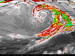
Left: March 20, 1995, 15:00 ZULU. This bad boy compelled the National Weather Service, Portland, to post this warning at 10 PM PST March 19, 1995: " ..HIGH WIND WARNING FOR THE COAST TONIGHT AND MONDAY... "HIGH WIND WARNING IS NOW IN EFFECT FOR THE OREGON COAST. WINDS ALONG THE COAST WILL INCREASE TONIGHT AND BECOME 35 TO 45 MPH WITH GUSTS TO 75 MPH IN THE NORTH AND NEAR 90 MPH IN THE SOUTH AHEAD OF THE COLD FRONT. WINDS HAVE ALREADY GUSTED TO 40 MPH AT SEA LION CAVES...59 MPH AT GOLD BEACH...AND 94 MPH AT CAPE BLANCO." |
The above storm is a very potent form of midlatitude cyclone. Many have struck the West Coast within the relatively short period of meteorlogical record. These systems can match a Category 3 hurricane in both minimum central pressures and sustained wind speeds. Such storms have a reach far beyond that of a typical hurricane: they can throw a cold rain into the Alaska Panhandle while at the same time pummel the San Francisco Bay Area with a warm, saturated gale. These tempests are killers, and can cause damage into the hundreds of millions, even billions. The focus of these web pages is on midlatitude cyclones; though, as weather and climate contain varied and diverse phenomena, other types of events are also examined. This website is here to dispell certain weather myths. There seems to be an idea that severe weather somehow doesn't strike the Pacific Northwest. This seems to be largely an eastern misconception. For example: The March 12-13, 1993 "Storm of the Century" has been touted as the strongest extratropical storm to strike the United States in the 20th century. This appears wrong on a number of counts. An argument could be made that the great Columbus Day Storm of 1962 holds the "Storm of the Century" title, and for good reason. Sure, the 1993 storm produced more lowland snow; the Columbus Day Storm was a relatively warm system and snow just didn't happen, save maybe at the highest elevations. However, let's talk wind. Wind generally causes more damage than snow. Sure, when snow gets deep enough, it can become a problem for roofs. However, for much of the region that saw snow during the 1993 event, accumulation just didn't reach such proportions; 6-10" was common. Of the storms on record, only eastern hurricanes, possibly some wake low events, and some thundergusts match the strength of winds reported during the Columbus Day Storm. I checked the Storm Data for the March 1993 event. The supposed "Storm of the Century" just doesn't come close to the peak gusts officially recorded during the Columbus Day Storm. Generally, for March 1993 the peaks were in the range of 50 to 70 mph, with a few ranging up to 75 to 83 mph. Most of the latter readings happened at coastal stations. For the Columbus Day Storm, official wind gusts reached 127 mph in the Willamette Valley. Many stations had gusts between 75 and 100 mph, and this includes quite a few locations that were inland (including Corvallis). So much for the storm of 1993! One of the main foci of the case studies below is to demonstrate severe weather events in the Pacific Northwest. |
New Additions January 2007: |
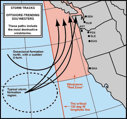
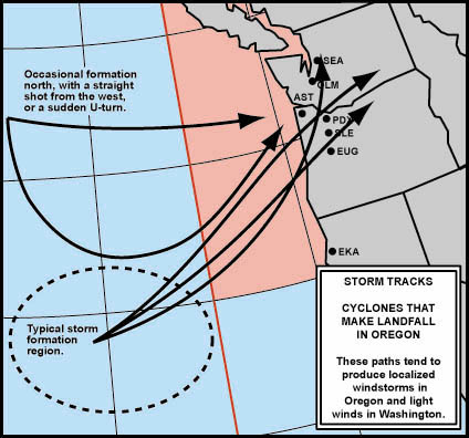
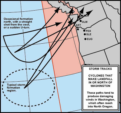
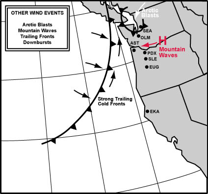
Windstorm Events Roughly Broken Down by Track Type Placement of some storms in certain categories is tentative, especially for those that haven't been given a webpage at this time. And, like most category systems, this one is far from perfect. Gray areas exist: The difference between the offshore-trending southwesters that skim ashore on Washington's Olympic Peninsula, and those that dive more directly into Washington (moving in from the SW instead of SSW, which puts such storms in the washington landfall category), are fairly subtle, and arguments can be made for moving one or the other subtype across the main categories. Listed events without links are on the "to do" list. |
Group 1: Offshore-Trending Sou'westers--Often the Major Events |
The Double Windstorms of December 21-22, 1955 |
The New Year's Day Storm of January 1, 1997 |
Group 2: Oregon Landfalls--Some of Oregon's Strongest Storms |
The Sudden Blast of January 10-11, 1988 |
Group 3: Washington Landfalls--Some of Washington's Strongest Storms |
The Strong Storm of January 15, 1951 |
The Windstorm of December 20, 1961 |
The Powerful Windstorm of January 19, 1964 |
Kitsap Blowdown of February 13, 1979: So Long Hood Canal Bridge |
The Underachieving Cyclone of January 18, 1996 |
The February 4, 2006 Windstorm |
The Strong December 14-15, 2006 Windstorm |
Group 4: Other Wind Events--Includes Powerful Local Gales |
"Hey, what about the rest of California?" For all you San Francisco Bay Area storm watchers who think I'm focused too far north, I suggest taking a look at Jan Null's "Bay Area Storm Index" (BASI), if you haven't already seen it: http://ggweather.com/basi_archive.htm It's a very cool way of gauging the big baddies of the Bay Area. "Okay, but what about SoCal?" What--there's weather down there? |
For their generosity with help and information, I thank the folk at the National Climatic Data Center, the Western Region Climate Center, the National Weather Service, especially those people working at the Eureka, Portland and Seattle offices, the National Data Buoy Center, the Oregon Climate Service, the University of Washington Department of Atmospheric Sciences, and the Oregon Historical Society. Without the efforts of the people working at these organizations, the information provided on these pages wouldn't have been available. Thank you doing for a great job! Copyright Notice: All text, graphics, photos and illustrations on the pages of this storm-related website are copyright 1981-2007 by Wolf Read, hereafter referred to as the author/illistrator, unless stated otherwise. This website is intended to help educate the public on dangerous Pacific Northwest storms, and, as it is also a research project in progress, to provide some groundwork for those interested in doing storm research for themselves. In keeping with that direction, and in the tradition of scientific information sharing, permission for reproducing material on this website will be granted, provided that these conditions are met: 1) credit is clearly given to the author/illustrator and this website in the reproduction, and 2) the author/illustrator is notified of how and where the material is being used (e-mail link below). Note that this permission can only be extended to material created by the author/illustrator. Thanks for visiting this website! |
Page Last Modified: January 11, 2007 Project Started: October 17, 2000 You can reach Wolf via e-mail by clicking here (Please note that I'm very busy, and can take a fair amount of time to respond to e-mail.) |