|
When a North Gale Blows: a perspective by Wolf Read |
|
For the second time in December 1990, arctic air rushed southward out of the Frasier River Valley and funneled down Washington's Puget Sound, this time on the 28th. This cold, dense air hugged the surface, and felt the region's craggy topography. Hillsides deflected the onrushing chunk of atmosphere, forests slowed parts of it down as it poured inland, off the relatively flat water. Many regions experienced a frigid, blustery day, with little evidence of the destruction taking place in select locations along the state's waterways. Shorelines and bluffs with a northern exposure took the brunt of the wind. For those locations, the Arctic blast may as well have been a hurricane. Shoreline forests fell apart at the cold wind's touch, and the broken trees landed on those homes hugging the bluffs. These very same houses were often sheltered from the south to southwest winds of a more typical windstorm, for the land and trees behind them blocked a normal winter gale's lashing gusts. Two fatalities occurred from trees impacting the cars that the victims occupied, one in Anacortes, and the other on Vashon Island. An initial sign of trouble for places exposed to northerly winds occurred about ten days before, when the first arctic front arrived on the 18th and 19th. Though the wind gusts generally weren't quite as strong as during the second cold surge, they were forceful enough to damage a pier at Seabeck, knock out power to many customers in the Northwest Interior, and also cause two fatalities, one from a spinout on black ice, and the other from a falling tree on Bainbridge Island. Plenty of snow arrived with the first arctic strike, especially in areas prone to the effects of the Puget Sound convergence zone: 6 to 14 inches of snow fell from downtown Seattle to Everett, with about 1 to 4 inches elsewhere. The second arctic blast happened to be drier, with maximum snowfalls around 6 inches at Kent, and many places in western Washington just receiving a trace to a few inches. At the time, my home was in Pocatello, Idaho. However, during the second half of December 1990, I visited my parents for the holidays. They lived on Capitol Hill in Seattle, and this put me in the middle of this unusual storm. Here's what I wrote in my journal: |
|
|
Some Photographs of Damage from the December 1990 Northerly Gale |
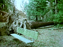
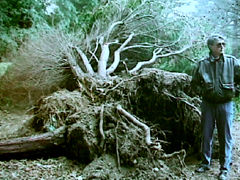
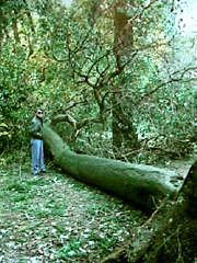
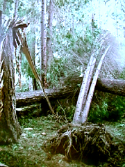
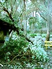
| Photo 1, below, Lincoln Park, West Seattle. Cozy bench. The root mass also pulled up a pipe. | Photo 2, below, Lincoln Park, West Seattle. Three trees uprooted, probably triggered by the fall of the Douglas-fir to the right, behind my dad. |
|
|
|
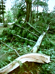
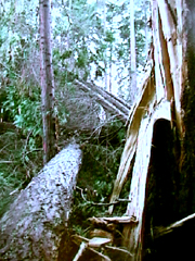
| Photo 3, below, Lincoln Park, West Seattle. Douglas-fir "branch". This tree was growing strangely, and was probably weakened by this fact. | Photo 4, below, Lincoln Park, West Seattle. Large Pacific madrona uprooted in the gale. |
|
|
|
| Photo 5, below, Lincoln Park, West Seattle. These trees just missed this building. | Photo 6, below, Lincoln Park, West Seattle. Major pile-up of different tree species. |
|
|
|
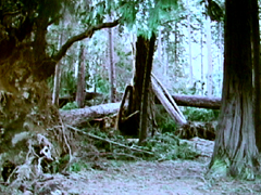
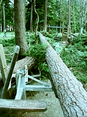
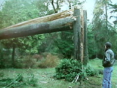
| Photo 7, below, Lincoln Park, West Seattle. A couple of Douglas-firs decided to try out this picnic table, with disasterous results. | Photo 8, below, Lincoln Park, West Seattle. Another jumble like the one above. This kind of scene was increasingly common towards the park's north end. |
|
|
|
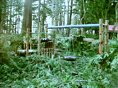
| Photo 9, below, Lincoln Park, West Seattle. Children's playground buried, and damaged, by several trees. | Photo 10, below, Lincoln Park, West Seattle. This tree was simply shattered by the gale. |
|
|
|
| Photo 11, below, Lincoln Park, West Seattle. Another reminder of Nature's force. | Photo 12, below, Lincoln Park, West Seattle. This restroom was damaged by a Pacific madrona. |
|
|
|
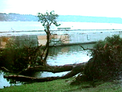
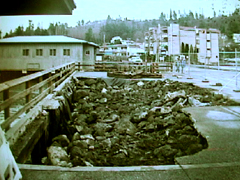
| Photo 13, below, Seward Park, Seattle. The wind and waves moved one of the surviving pieces of the Lacy V. Marrow floating bridge (which broke apart and sunk in a rain and wind strom in November 1990). The motion pulled down this madrona, and several others that were being used as moorings. | Photo 14, below, Redondo Beach Walkway. This north-facing shorline was pounded by large waves during the Arctic gale, and part of it fell in. By the time I took this photo, work crews had filled the hole with rocks. A large expanse of the walkway and road behind me was also lost to the storm. |
|
|
|
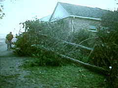
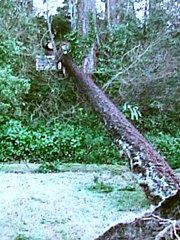
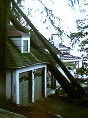
| Photo 15, below, Puget Sound shoreline, south of Seattle. This Douglas-fir landed on a house, which can barely be seen in the dense shrubbery. | Photo 16, below, Puget Sound shorline, south of Seattle. Another house stricken by felled trees, with some roof damage. |
|
|
|
| Table 1, below, lists the peak wind and gust observed during the December 1990 arctic outbreak at the 11 key stations used for windstorm strength comparisons on this website, as provided by the National Climatic Data Center through their Climate Visualization database, Local Climatological Data, and raw Surface Weather Observation forms.
The focus of the highest winds was clearly in Washington, especially in the Northwest Interior and less so in the Puget Lowlands. Oregon got the cold air, but it arrived on a modest breeze that wouldn't be atypical of a hot summer day. |
| Location |
Peak |
Direction |
Obs Time of |
Peak |
Direction |
Obs Time of |
| California: | ||||||
| Arcata |
17 |
350 |
14:56 HRS, 28th |
23 |
350 |
14:56 HRS, 28th |
| Oregon: | ||||||
| North Bend |
20 |
330 |
15:48 HRS, 28th |
26 |
330 |
15:48 HRS, 28th |
| Astoria |
28 |
320 |
--, 28th |
36 |
NW |
--, 28th |
| Medford |
12 |
300 |
13:00 HRS, 28th |
16 |
NE |
--, 28th |
| Eugene |
15 |
010 |
19:00 HRS, 28th |
20 |
N |
--, 28th |
| Salem |
16 |
020 |
16:00 HRS, 28th |
24 |
N |
--, 28th |
| Portland [1] |
25 |
330 |
16:00 HRS, 28th |
32 |
NW |
--, 28th |
| Washington: | ||||||
| Quillayute |
28 |
060 |
10:00 HRS, 28th |
39 |
NE |
--, 28th |
| Olympia |
21 |
060 |
--, 28th |
36 |
NE |
--, 28th |
| Sea-Tac |
30 |
350 |
07:00 HRS, 28th |
46 |
N |
--, 28th |
| Bellingham [2] |
40 |
030 |
00:51 HRS, 28th |
63 |
030 |
00:48 HRS, 28th |
| AVERAGE |
22.9 |
000 |
32.8 |
|
||
| [1] Peak wind at Portland is the last of two occurrences, the other having occurred out of 330 degrees at 13:00.
[2] Peak wind at Bellingham is the first of two occurrences, the other having occurred out of 040 degrees at 01:53. |
||||||
| Table 2, below, simply lists observed peak gusts during the December 1990 arctic outbreak at a fairly broad array of stations, as provided by the National Climatic Data Center through their Climate Visualization database, Local Climatological Data, raw Surface Weather Observation forms, and Storm Data publication. Some peak gusts are from the National Data Buoy Center historical data.
Wind velocities weren't particularly noteworthy in much of Oregon, with many stations, including some not listed such as Aurora, Troutdale and Roseburg, barely showing a moderate breeze (13-18 mph) as the colder, drier air poured into the region. Even in Washington, where the wind gusts became quite forceful at times in some areas, the official readings aren't incredibly fast relative to other wind events in Pacific Northwest history. Given the amount of damage to trees on December 28, 1990, this serves to emphasize how wind direction can play an important role in the way a particular wind velocity effects things. High winds out of the north are rare in the western Pacific Northwest, and trees that have developed to endure more frequent strong winds from the south aren't necessarily prepared for a northerly onslaught. An exception to this idea is, perhaps, in the Willamette Valley, where summer breezes with gusts in the range of 20 to 30 mph out of the north and northwest aren't uncommon. Trees in the Valley appear to be adapted rather well to wind loading out of the north. Indeed, in some locations, most trees have a slight lean toward the south, the northerly summer breeze is so prevalent. |
| Location |
Peak Gust
|
| Oregon: | |
| Medford |
16 mph
|
| Eugene |
20 mph
|
| Salem |
24 mph
|
| Portland |
32 mph
|
| Astoria |
36 mph
|
| Washington: | |
| Toledo |
24 mph
|
| Olympia |
36 mph
|
| Tacoma FAA |
47 mph
|
| Tacoma McChord AFB |
47 mph
|
| Renton |
49 mph
|
| SeaTac |
46 mph
|
| Seattle City NWS Office |
45 mph
|
| Seattle Boeing Field |
40 mph
|
| Seattle Alki Point |
58 mph
|
| Seattle West Point |
55 mph
|
| Everett |
32 mph
|
| Bremerton |
46 mph
|
| Hood Canal |
78 mph
|
| Hoquiam |
23 mph (1-minute avg)
|
| Quillayute |
39 mph
|
| Tatoosh Island |
51 mph
|
| Port Angeles |
25 mph
|
| Friday Harbor |
40 mph
|
| Smith Island |
59 mph
|
| Whidbey Island NAS |
59 mph
|
| Bellingham |
63 mph
|
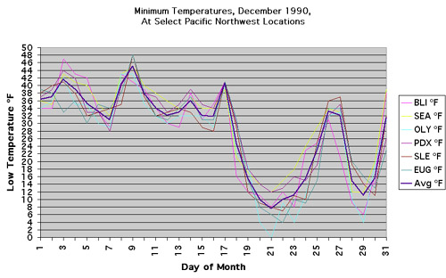
| Graph 1, below, charts the temperatures for several Pacific Northwest Locations. The second sharp dip in low temperatures was a product of the damaging Arctic gale. The first, stronger dip was the product of a huge Arctic outbreak throughout the western United States. Pocatello, ID, where I was at the peak of this major cold spell, had a low of -29º F on the morning of the 21st, and temperatures didn't go above -9º F for a 72 hour period. Some of these lows are records. |
|
|
Last Modified: February 16, 2006 You can reach Wolf via e-mail by clicking here. | Back | |