The Surprise Windstorm of March 16, 1984 by Wolf Read |
|
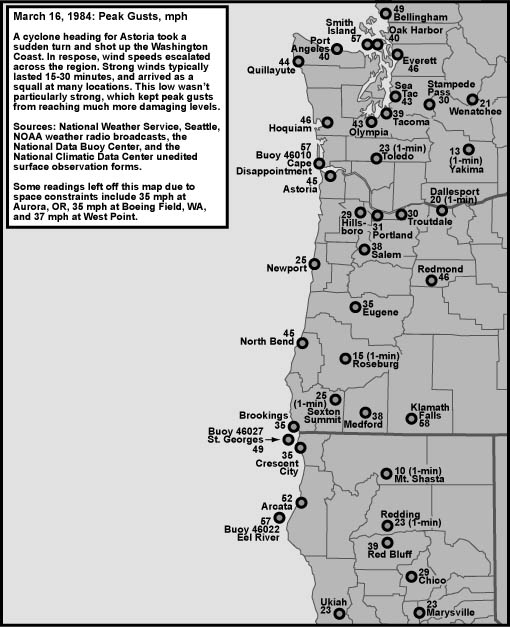
The sudden storm of March 16, 1984 offered up a surprise for Seattle area forecasters. This cyclone was expected to make landfall near Astoria, a path that significantly reduced the possibility that Western Washington would receive damaing winds. Instead, the low took a sudden turn to the north, and raced into Vancouver Island while hugging the Washington coast. As the storm surged northward, a brief period of 30 to 45 mph gusts--in some places 46 to 60 mph--surged across the coast and interior of the Evergreen State. As the wind roared, trees fell and power was interrupted in many areas. In my journal, I noted: |
|
| In 1984, my primary meteorological information source was NOAA weather radio. I clearly recall the high wind warning alarm firing off immediately after the highest wind period at my location on March 16, 1984, though I didn't note this in my journal. Most of the wind readings listed above are from the available observations broadcast over the radio, which sometimes didn't include actual peak gust information. Thus, some of the above readings will be different from those taken from the official surface observation forms and used in the peak gust map above and the data table below. |
General Storm Data Table 1, below, is a list of the lowest barometric pressures, and time of occurence, from the March 16, 1984 windstorm. Pressures for this event fell within the range of a typical winter storm for the Pacific Northwest, and none of the readings are particularly noteworthy. Source: Microfilm copies of the unedited surface observation forms, obtained from the National Climatic Data Center. |
|
Table 2, below, is a list of the maximum pressure gradients, and time of occurrence, for the March 16, 1984 windstorm. These gradients are, well, pathetic. None of the values are particularly strong, and, like with the minimum pressures, they are fairly typical of winter storms in the Pacific Northwest. This table serves as a reminder that, sometimes, gradients can be deceiving when trying to discern wind potential. Maybe another way to look at this table is that, relatively speaking, this storm was a bit of an overachiever! For those interested, the peak PDX-BLI measure was 8.6 mb at 01:00 and 02:00 on March 17th. Source: Microfilm copies of the unedited surface observation forms, obtained from the National Climatic Data Center. |
|
Table 2 Notes: [1] These readings denote the first of several occurences. |
Table 3, below, lists the peak wind and gust for eleven key stations in the Pacific Northwest, their direction, and their time of occurrence. "Peak Wind" is a 1-minute average, and "Peak Gust" is an instant (approx 1-second) average. By my own personal methodology, an wind event rates the term "windstorm" when the average peak gust of these eleven stations reaches 39.0 mph (gale force) or higher. The March 16, 1984 cyclone is a minor windstorm. Moderate windstorms have an average of 45.0 to 54.9, and major windstorms are those that reach or exceed 55.0. Only a handfull of storms have made the majors, including December 12, 1995, November 14, 1981 and October 12, 1962. Portland appears to have been the least affected by this wind event, though it is probably telling that the peak 1-min is higher for Portland than other Willamette Valley locations, and that Portland's peak gust was much earlier than the peak wind. This suggests the possibility of higher gusts than 31 mph during the peak wind timeframe. Arcata's powerful winds stand out most strongly among all the stations with a peak sustained value in gale-force range. This storm approached some of the big events in history for that location. Save for the readings at Arcata, there's a remarkable uniformity among wind speeds between the stations, a rare event, for usually coastal stations such as North Bend and Astoria show wind speeds 10-20 mph faster than interior locations. This may partly explain this storm's surprise attack in the Washington Interior. The regularly-reporting coastal stations didn't report wind speeds that suggested a gale would strike inland. This even includes stations not in the list, such as Hoquiam, which had a peak gust of 46 mph. Sources: National Climatic Data Center, undedited surface observation forms. |
| Location | Peak |
Direction |
Obs Time of |
Peak |
Direction |
Obs Time of |
| California: | ||||||
| Arcata | 40 |
240º |
13:40 HRS, 16th |
52 |
240º |
13:41 HRS, 16th |
| Oregon: | ||||||
| North Bend | 28 |
190º |
12:52 HRS, 16th |
45 |
190º |
11:54 HRS, 16th |
| Astoria | 29 |
200º |
18:50 HRS, 16th |
45 |
180º |
18:26 HRS, 16th |
| Medford | 21 |
140º |
13:50 HRS, 16th |
38 |
140º |
12:16 HRS, 16th |
| Eugene | 23 |
160º |
11:47 HRS, 16th |
35 |
180º |
15:02 HRS, 16th |
| Salem | 21 |
180º |
17:50 HRS, 16th |
38 |
180º |
12:10 HRS, 16th |
| Portland | 25 |
190º |
17:48 HRS, 16th |
31 |
140º |
13:23 HRS, 16th |
| Washington: | ||||||
| Quillayute | 20 |
150º |
21:26 HRS, 16th |
44 |
150º |
22:20 HRS, 16th |
| Olympia | 18 |
180º |
22:50 HRS, 16th |
43 |
180º |
19:05 HRS, 16th |
| Seattle | 29 |
220º |
20:10 HRS, 16th |
43 |
220º |
20:08 HRS, 16th |
| Bellingham | 26 |
170º |
23:54 HRS, 16th |
49 |
120º |
01:35 HRS, 17th |
| AVERAGE | 25.5 |
184º |
42.1 |
175º |
References [1] March 1984. |
Last Modified: February 26, 2003 You can reach Wolf via e-mail by clicking here. | Back | |