Comparative Examination of Windstorms

Class 1 Events

compiled by

Wolf Read

Class 1: Cyclones That Track Into Southwest Oregon

Class 1 windstorms have produced some of the strongest short-distance gradients out of all PNW windstorms, and the fastest atmospheric pressure tendencies. For some events, barograph traces resemble those of hurricanes. It appears that these pressure extremes can be attributed to, in part, the fact that storms with such southerly tracks are often deep in the battle ground between the tendency for higher pressure over California and troughiness over Washington and British Columbia; the lows often ride right over the north end of a high pressure ridge, offering ample opportunity for strong gradients. The focus of these storms’ high winds tends to be very tightly constrained by the southerly track as well, partly due to high pressure to the south, and also due to the imposing barrier represented by the Klamath-Siskyou Mountains.

10 Nov 1975

10 Nov 1975: In terms of pressure gradients, this 975 mb storm was the most intense Class-1 event identified from 1948-2004. Peak gradients reached about +30.0 mb from ACV-OTH. A pressure surge of +16.6 mb in one hour at OTH is on par with many strong hurricanes in the record for the Eastern U.S. Out of all the windstorms examined for this paper, the peak gust of 65 knots at Roseburg, a fairly wind-sheltered location, is the highest velocity recorded for this station. The geostrophic potential based on an incredible gradient of 24 mb over 100 statute miles on the south side of the storm was around 230 knots, which translates to a potential of 115 knot 1-minute wind, with gusts around 160. The northeast track suggests that upper winds were more from the southwest to west, a direction that probably did not offer strong support for ageostrophic south winds in confined north-south valleys. This probably spared the inland regions from even stronger winds than those recorded. Interestingly, an unusually strong negative gradient set up on the north side of the storm, with the –6.9 mb EUG-PDX reading corresponding to a geostrophic potential of 65 knots. This resulted in fairly brisk northerly winds over much of the region, including gale-force gusts at Eugene.

15 Nov 1994

15 Nov 1994: This 994 mb cyclone moved into the Oregon waters from the northwest, then curved to the east and east-northeast as it slowly moved into the state. As the cyclone drifted ashore, the storm was clearly in a mature, if but degrading state. This made for a less intense event overall compared to the others described in this section. Nevertheless, wind velocities reached damaging levels, especially on the coast. Of particular interest was the northwest to north gale just north of the storm’s track, which ravaged Newport and apparently caused trees, normally sheltered from the typical south winds, to fall at unexpected locations.

07 Feb 2002

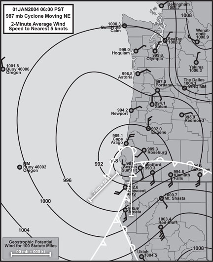
07 Feb 2002: This 994 mb windstorm developed rapidly inside 130º W, and therefore was generally missed by the offshore buoy network. High winds with this storm were particularly violent over a very narrow stretch of land. Peak short-distance gradients included +9.0 mb RBG-EUG and +6.0 mb EUG-CVO. Unlike other storms in this class, positive gradients behind the storm exceeded the maximum negative gradients ahead of the low for stations north of the track. The reversal from strong negative to strong positive was sudden, especially in Oregon, happening within the space of two hours. The sharp reversal negative to positive is likely a reflection of a strong northeasterly track. For comparison to other events, peak negative gradients included -7.1 mb OTH-AST, -2.2 mb AST-UIL, -5.4 mb EUG-PDX, -2.6 mb PDX-SEA and -3.9 mb SEA-BLI.

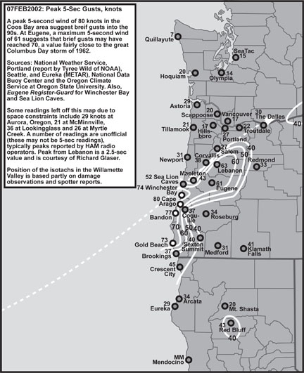
A particularly well-developed bent-back occlusion appears to have enhanced the pressure gradient in a small region near the core of the 07 Feb 2002 storm; the cyclone’s strongest winds followed the tip of this front, generally sweeping a swath about 25 to 50 statute miles wide. See Steenburg and Mass [1] for a detailed analysis of the dynamics of bent-back fronts in a Pacific Northwest storm. At Cape Arago, 2-minute average winds reached 65 knots, with a 5-second gust to 81, the expected results for a Category-I hurricane! At North Bend, a 1-hour pressure surge of +14.2 mb also had the flavor of a hurricane. In the Willamette Valley, pressure tendencies matched those of the infamous Columbus Day storm of 1962. The ASOS station at Eugene measured a peak 2-minute wind of 52 knots with a 5-second gust to 61 at the height of the storm, readings that are likely second only to the Columbus Day storm for the 1948-2004 period. The geostrophic potential for the pressure gradient over 100 statute miles on the south side of the storm reached about 150 knots, and on the southwest side of the storm 125 knots. The latter supports the measured winds at Cape Arago quite nicely.

The morning after the 07 Feb 2002 storm struck the South Willamette Valley, the author toured the region by car. Of interest was strong indication of narrow lines of extreme wind that caused extensive damage, with areas to either side relatively unharmed. There appeared to be a “background” wind of about 30 knots with gusts to 45 in most places affected by the storm, with wind velocities apparently escalating to 50-60 knots with gusts in the range of 60-70, perhaps higher, in the narrow bands of very high wind. Some of these lines continued for long distances across the valley. One such band seemed to extend from the Eugene Mahlon Sweet Field to Junction City and then beyond. Woodlots impacted by the high-wind bands suffered heavy tree damage, with as much as 25% of trees being broken or uprooted. Lines of power poles were broken in places, in some cases for lengths of a kilometer. Near the junction of I-5 and state highway 228, a steel power pole buckled under the force of the gale.

01 Jan 2004

01 Jan 2004: This 986 mb cyclone developed rapidly just off the northern California coast in a manner similar to 07 Feb 2002, but lacked some of the intensity despite being 8 mb deeper. This cyclone pulled cold air eastward through the Columbia River Gorge and then south into the Willamette Valley, where snow fell along with brisk north winds in a classic winter-weather scenario. South of the track, Gold Beach had gusts to 80 knots, and a full blizzard struck Klamath Falls, with gusts to 57 knots. Heavy snow and thunder swept across southern Idaho as the low moved inland--with a good barotropic zone and strong jet support, this system maintained integrity as it moved through the western mountains.

Incidentally, this cyclone tracked so far south that it is a marginal example of a Class 1 event--might have to include a Class 0 category: "Cyclones that track into Northern California," of which a particularly intense example occurred on December 31, 2005.

References

[1] Steenburgh, W. James, and Mass, Clifford F., "Interaction of an intense Extratropical Cyclone with Coastal Orography," Monthly Weather Review, July 1996, Vol 124, pp 1329-1352.

Last Modified: September 21, 2007
Page Created: February 10, 2006

You can reach Wolf via e-mail by clicking here.

| Back |