Strong Gale of April 23, 1943 compiled by Wolf Read |
|
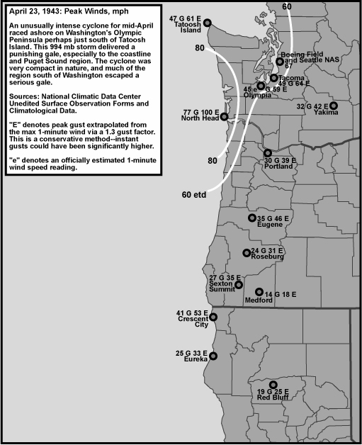
The year 1943 was visited by the rare April windstorm, and this one fairly late in the month, on the 23rd. The low center moved in out of the southwest and passed very close to Tatoosh Island, perhaps just to the south, on its way inland. A very strong pressure surge accompanied the passage of the low at Tatoosh, along with a heavy thunderstorm. The low was at least a 994 mb storm, and a very potent one at that. Compared to many windstorms, this central pressure doesn't seem very high, but history bears out that these lows can be fairly destructive. Cyclones with a similar depth caused significant Pacific Northwest gales on November 15, 1994 and February 7, 2002, among others. For Washington coastal stations, April was the most unsettled month of the 1942-43 season! The U.S. Department of Commerce Weather Bureau reported, in the Monthly Meteorological Summary publication for North Head, Washington, April 1943: "There were eight gales during the month, five of them coming during the last half. It was the stormiest month of the 1942-43 season. On the night of the 22-23rd the most severe April storm of record struck North head shortly after 11 p.m. A southeasterly wind during the evening became southerly and rapidly increased to gale and hurricane proportions. An average velocity of over 60 miles per hour was maintained for over five hours beginning at 12:15 a.m. The maximum velocity [of] 77 miles per hour . . . was the sixth highest wind of record at North Head." (Emphasis added.) The same report mentioned garages being overturned by the wind on the Washington coast, damaged businesses and residences, and smashed plate-glass windows. Telephone, telegraph and power interruption also occurred, but wasn't as extensive as in past storms. Two fishing boats were sunk and about 20 others were damaged in Baker Bay. Docks also suffered damage, and the Government dredge Multnomah suffered the loss of 40 pontoons that supported the pipeline from the dredge to the port dock. |
General Storm Data Table 1, below, lists the barometric minimums for the April 23, 1943 storm at selected sites. Compared to many storms of history, these pressures aren't very low. But they were low enough, and a strong gradient across western Washington was established. Source: Hourly data are from the National Climatic Data Center, unedited surface observation forms. |
Table 1 Notes: [1] Last of six hourly reports in a row with the same reading. [2] Last of two hourly reports in a row with the same reading. [3] Last of three hourly reports in a row with the same reading. |
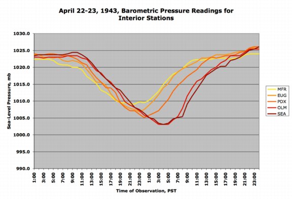
Figure 1, below, shows fairly active barometers for interior stations. On the absolute scale, pressures didn't get strongly low, but on the relative scale, Washington stations showed a pretty good drop, falling about 0.60", or 20.0 mb, during the course of the storm. Many windstorms produce 0.70" to 1.00" (23 to 30 mb) drops, so the April 23, 1943 windstorm was a bit short, but not by much. Source: Hourly data are from the National Climatic Data Center, unedited surface observation forms. |

Table 2, below, lists the maximum gradients for some approximately standard measures during the April 23, 1943 cyclone. Eureka sits in for Arcata. The coastal gradient in this storm was quite strong, and approached values achieved by the Big Three. Inland, the numbers are quite strong for the PDX-SEA measure, with slackening gradient southward, which reflects the lower wind speeds in Oregon verses Washington. Source: Hourly data are from the National Climatic Data Center, unedited surface observation forms. |
|
Pressure Tendencies The April 23, 1943 windstorm brought with it a decent "pressure couplet" over much of Washington. Strong pressure changes (+/-3.0 mb and higher) occurred from about Portland northward. Table 3, below, shows the maximum hourly changes in pressure for seven key stations in the Pacific Northwest. The +6.1 mb (+0.18") hourly surge at Tatoosh Island is among the highest for that particular station, though it is shy of the December 21, 1940 windstorm, which produced a +8.5 mb (+0.25") surge. Not even the Columbus Day storm, with a decidedly strong +6.2 mb (+0.18") surge, matched the December 4, 1945 storm. Source: Microfilm copies of the unedited surface observation forms, obtained from the National Climatic Data Center. |
Table 3 Notes: [1] The +1.4 mb climb at Eureka is the last of two occurrences, the other having happened at 22:00 on the 22nd. [2] The -1.7 mb drop at Seattle is the last of four occurrences on the 22nd. |
||||||||||||||||||||||||||||||||||||||||||||||||||||||||||||||||||||||
Table 4, below, lists the peak wind and gust for seven key stations in the Pacific Northwest, their direction, and their time of occurrence. "Peak Wind" is a 1-minute average, and "Peak Gust" is an instant reading. By my own personal methodology, a wind event rates the term "windstorm" when the average peak gust of eleven key stations reaches 39.0 mph (gale force) or higher. The April 23, 1943 windstorm surpassed this threshold, and rushed right into moderate windstorm category. Moderate windstorms have an average of 45.0 to 54.9, and major windstorms are those that reach or exceed 55.0. Only a handful of storms have made the majors, including December 21, 1940, December 4, 1945, December 12, 1995, November 14, 1981 and October 12, 1962. Due to missing stations, and lots of extrapolated gusts, it's a bit of a stretch to compare the average values of this storm to those of later storms where the eleven stations and peak gusts are available. However, the maximum 1-minute winds for Boeing Field, with the measured gust to 67 mph, reflect a very potent windstorm in the Seattle Area. These values are comparable to the Columbus Day storm of 1962 and the Inauguration Day Storm of 1993. It's rather amazing that such a strong Seattle storm occurred so far into spring, but April gales aren't unprecedented, with high wind events also happening in April of 1957 and 1962, among other years. Also, a strong windstorm occurred on May 5, 1880, possibly the latest spring high-wind event on record for Washington. Source: Hourly data are from the National Climatic Data Center, unedited surface observation forms. For stations where peak gust was not noted, a peak gust was estimated by applying a standard 1.3 gust factor--these values are in italics. |
| Location | Peak |
Direction |
Obs Time of |
Peak |
Direction |
Obs Time of |
| California: | ||||||
| Eureka | 25 |
SSE |
18:10 HRS, 22nd |
33 |
SSE |
18:10 HRS, 22nd |
| Oregon: | ||||||
| Medford [1] | 14 |
SW |
00:30 HRS, 23rd |
18 |
SW |
00:30 HRS, 23rd |
| Eugene | 35 |
SW |
00:49 HRS, 23rd |
46 |
SW |
00:49 HRS, 23rd |
| Portland | 30 |
S |
09:30 HRS, 23rd |
39 |
S |
09:30 HRS, 23rd |
| Washington: | ||||||
| N. Head [2] | 77 |
S |
02:35 HRS, 23rd |
100 |
S |
02:35 HRS, 23rd |
| Tatoosh I. | 47 |
NW |
07:15 HRS, 23rd |
61 |
NW |
07:15 HRS, 23rd |
| Olympia | 45 E |
S |
06:30 HRS, 23rd |
59 |
S |
06:30 HRS, 23rd |
| Seattle Boeing | 52 |
S |
08:00 HRS, 23rd |
67 |
S |
06:45 HRS, 23rd |
| AVERAGE | 40.6 |
SSW |
52.9 |
SSW |
Table 4 Notes: [1] Peak wind at Medford last of two occurrences, the other having happened at 23:58 HRS on the 22nd. [2] North Head data from the Weather Bureau's Monthly Meteorological Summary. |
Last Modified: April 30, 2004 You can reach Wolf via e-mail by clicking here. | Back | |