What a Blast: The Arctic-Air Outbreak of February 1989
February, 2019
This edition of the OWSC newsletter more or less coincides with the 30th anniversary of the severe cold snap of early February 1989. Last month we reviewed the record warm anomalies that occurred in January 1953; perhaps it makes some sense to take a look at the other side of the coin. Moreover, the record cold experienced in the Midwestern US during the last week of January made those of us that are fond of cold weather reminiscence about colder than normal weather in our neck of the woods.
The stage was set for our event in Alaska during late January 1989. Bitterly cold air masses are no stranger in the interior of the 49th state, but this one was a doozy. For example, every single day during the last two weeks of the month included temperatures at least 40 degrees below normal in Tanana, AK with the temperature bottoming out at -76°F on 27 January. The all-time maximum sea level pressure record for North America of 1078.6 hPa was set at Northway, AK on 31 January due to the massive Arctic high associated with the frigid air. A major change in the hemispheric atmospheric circulation pattern near the beginning of February brought relief for Alaska (it actually became unusually warm by the second week of the month) and some big changes for the lower 48, including Washington.
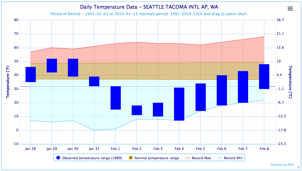
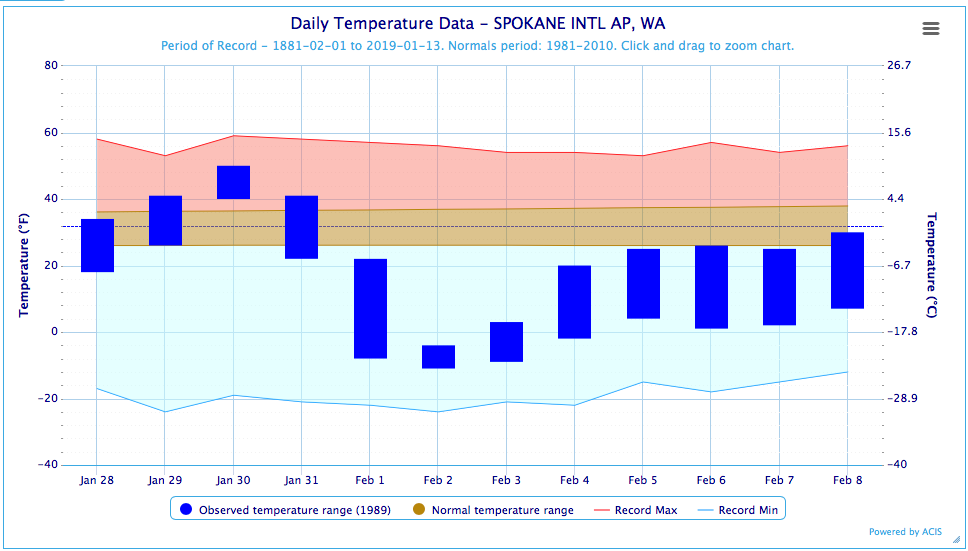
The cooling is summarized here in terms of the maximum and minimum temperatures recorded at Sea-Tac (KSEA) and Spokane International (KGEG) Airports from 28 January through 8 February 1989, as plotted in Figure 1. The coldest temperature at Sea-Tac was 7°F on 4 February, with daily minimum temperature records set during 4 days in a row. The average temperatures on 2 and 3 February were about 28°F below normal. But Spokane did even better in some ways. It was especially cold on 2 February; the combination of a maximum temperature of -4°F and a minimum temperature of -11°F represented an average temperature about 39°F below normal.
Remarkably, that night included winds of 15-17 knots (17-20 mph) at KGEG that mixed the lower atmosphere and likely disrupted the formation of a surface-based inversion. Without this wind, it is likely that the temperatures would have plummeted into the record territory of the -20s.
Speaking of winds, the aforementioned Arctic high brought very strong outflows through the Fraser River gap into the Bellingham area. Bellingham Airport (KBLI) observed sustainedwinds from the northeast as great as 48 mph with gusts to 73 mph (with temperatures in the single digits). These winds persisted considerably longer than typical with regional arctic-air outbreaks. The winds remained above either 35 mph sustained and/or 46 mph in terms of gust speeds during the 3-day period from 8 PM PST on 31 January through 8 PM on 3 February. This was also one of those rare situations for which it was evident that it was going to be plenty cold enough for snow, even in the lowlands of western WA. In this regards, the west side did relatively well with Sea-Tac receiving about 6” while Spokane checked in with only 1”. In other words this event was much more noteworthy in terms of temperatures rather than snowfall for most of the state.
Some previous research carried out by the OWSC backs up that contention. This research involved examining the relationship between the Madden- Julian Oscillation (MJO) and cold-air outbreaks in the Pacific NW. As part of this work, the intensity of cold-air outbreaks based on 5-day averages of 850 hPa air temperatures averaged over the Pacific Northwest, along with the strength of the 500 hPa winds from the north, were compiled to compare with indices for the state of the MJO. This exercise revealed that the 850 hPa temperatures during the early February 1989 event were the coldest of the entire analysis period of 1978 through 2014. The twice-daily weather balloon soundings from Quillayute, WA near the northwest corner of the state indicate an observed 850 hPa temperature as low as -18.1°C from the 1200 UTC sounding on 3 February 1989. This cold snap did not happen to coincide with a phase of the MJO that tends to be accompanied by chilly temperatures. On the other hand, the winter season of 1988-89 featured a strong La Niña and winter temperatures are usually colder than normal, especially after the first of the calendar year.
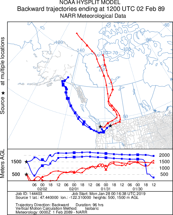
Past reviews of noteworthy events in our newsletter have often included 500 hPa geopotential height anomaly maps to summarize the overall atmospheric circulation. This time we thought of taking a different tack, with the goal of specifying the source(s) of the cold air that visited WA in early February 1989. This can be done through estimation of back trajectories using the HYSPLIT application maintained by NOAA’s Air Resources Laboratory. What we show here in Figure 2 are the estimated trajectories using the isobaric option, which essentially ignores vertical motions (which are prone to substantial errors). These results indicate continental origins for the air in both locations at the height of 500 meters (red lines), and southeast mainland Alaska as the source for the air at 1500 meters (blue lines). The latter’s journey over the ocean would have allowed it to pick up some moisture.
We close with musings about the prospects for a future arctic blast of comparable ferocity. It is definitely possible, but perhaps it would be a stretch to call it probable. As reviewed in this space in the monthly newsletter for January 2018, the incidence of monthly circulation patterns favoring extremely cold temperatures in WA has really dropped off in recent decades. In fact, February 1989 represents the last occurrence of either of the two coldest circulation patterns found in analysis of the period of 1948 through 2017. A repeat of the weather we enjoyed 30 years ago would require both the precursor build-up of exceptionally cold air, followed by evolution in the flow over western North America to deliver it to our backyards. With that said, I don’t think any of us at OWSC would have guessed a year ago that the Midwest would experience a record cold event of the magnitude of the one that just occurred, so we’re not discounting surprises in our own backyards. From a more local perspective, not that long ago there was little indication that there would be snow in the Puget Sound lowlands, with more apparently on the way!