The Yacolt Burn of 1902
September, 2015
This summer has included the largest fire (the Okanogan Complex) in WA state history and the most acres burned since at least 2002. The vast majority of wildfires in WA occur east of the Cascade Range crest but that is not the only part of state that can face a serious threat. In particular, prior to 2014, the largest fire in state history burned on the west flank of Cascades, the so-called Yacolt Burn of September 1902, which burned over 238,000 acres. There was little capability to fight large wildfires at that time, and the property damages and loss of life were exacerbated by the lack of reliable communication. On the other hand, the weather generally plays a critical role in severe fires in the Pacific Northwest (Gedalof et al. 2005) and it appears the Yacolt Burn was no exception. Our objective here is to briefly summarize conditions during the Yacolt Burn and determine how often similar conditions have arisen in recent decades.
The history of the Yacolt Burn is not fully known. It appears that the first fires may have begun in Oregon on 8 September, with embers crossing the Columbia into Washington state. Another fire started a day or two later near Stevenson, WA in the Columbia River gorge. It definitely seems that there were multiple points of ignition with separate fires merging into the conflagration.
The temperatures in the region of interest were abnormally warm but not extremely hot before and during the fire. The maximum temperatures from three nearby stations, Centralia and Vancouver, WA and Hood River, OR during the first 12 days of month were typically in the 80s or 6 to 8°F above normal, and no daily records were set. The historical accounts of this event generally include mention of strong east winds, and one description used the term “devil wind from eastern Washington”. Because of the probable importance of the east winds to the severity of the Yacolt Burn, here we will focus on that aspect of the regional weather conditions.
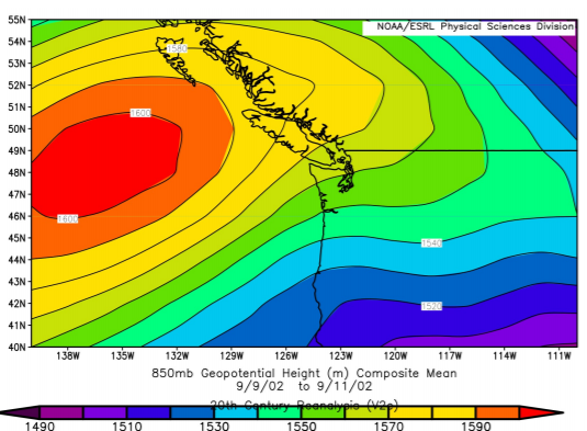
The NCEP 20th Century Reanalysis is used to document the regional flow at 850 hPa for the Yacolt Burn, and to identify other strong easterly events in the recent record (back to late 1940s). This product has a coarse spatial resolution and cannot be used to specify details in the specific location of the fire. Presumably it is suitable for comparing regional aspects of the circulation during the Yacolt Burn with similar events in the historical record. The distribution of mean 850 hPa geopotential height (Z) for the 3 days of 9-11 Sept 1902 is shown in Figure 1. This pattern was associated with a mean easterly wind of ~5 m/s in the general region of the fire. There was also a thermally-induced trough of low sea level pressure (SLP) at the coast (not shown); a hint of this feature is in the 850 hPa Z map included here.

As indicated above, the zonal winds at 850 hPa are used to ascertain when conditions comparable to those of the Yacolt Burn have occurred in recent decades. Specifically, 3-day average values of the zonal winds (U) at 850 hPa in SW WA were computed during the period of 15 August through 15 September for the years 1948 through 2014 in the region of the Yacolt fire.
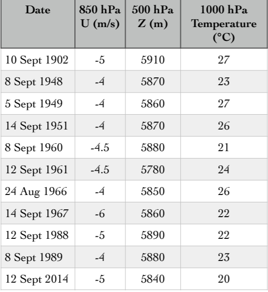
The 3-day periods with the 10 strongest mean easterly flow were examined individually. Table 1 itemizes the dates of these events, and approximate values for the 3-day means of the easterly flow (U) at 850 hPa, peak magnitude of 500 hPa ridge (Z), and 1000 hPa air temperature.

The cases identified on the basis of 850 hPa zonal winds can give insight into the conditions present during the Yacolt Burn. The atmospheric conditions during Yacolt Burn were more extreme than might be supposed based on surface air temperatures alone. There was one event found since the late 1940s with stronger east winds at the 850 hPa level (14 Sept 1967), but this case also included more moderate air temperatures. Our selection process revealed that strong easterlies are much more likely in early September than in late August. While temperatures are cooling off this time of year on average, the increased likelihood of winds promoting the growth of fires, and in many cases the continued drying of the landscape, may make early September the period of greatest fire threat west of the Cascade crest. Perhaps the rain we are receiving from the end of August into September 2015 is especially timely.
