Review of Winter 2020-21
May 6, 2021
As we head toward warmer temperatures, this is the time of year where we like to look back and review the WA state winter conditions. A moderate La Niña event developed early in fall of 2020, and the Climate Prediction Center (CPC) seasonal forecasts were calling for warmer and wetter than normal conditions for WA for the fall months. By November and December, however, a more typical La Niña response was predicted, with cooler and wetter conditions forecast for December through February (DJF) and January through March (JFM). So how did the winter actually play out? Here we summarize the winter ENSO conditions, average temperature and precipitation anomalies for WA, and corresponding snowpack with the current implications for summer water supplies.
La Niña conditions developed early in fall of 2020, and a moderate event persisted through the winter. Figure 1 shows the 3-month running mean of the sea-surface temperature (SST) anomalies for the Nino3.4 region of the equatorial Pacific Ocean (known as the Oceanic Nino Index) from 2013 through early 2021. The CPC issued a “La Niña Advisory” in September 2020, which happens to be still in effect at the time of this writing, and the SST anomalies in the equatorial Pacific Ocean were below -1°C for much of the winter. Currently, there is an expectation that the La Niña will transition to neutral conditions over the next several months. Early indications show about an equal chance of either La Niña or neutral conditions for winter 2021-22; we will be monitoring the state of the tropical Pacific because of its importance to the seasonal weather of the Pacific Northwest.
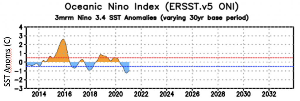
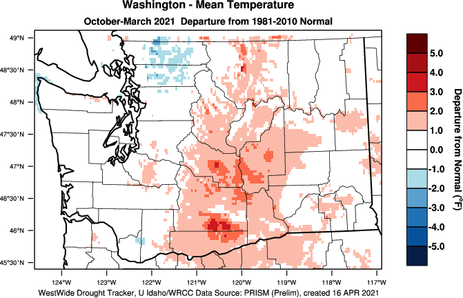
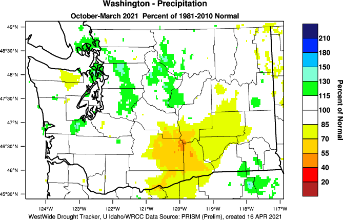
Figure 2 shows the departure from average temperature and percent of normal precipitation across the state from October 2020 through March 2021. Averaged statewide, both temperatures and precipitation were near-normal, with temperatures +0.9°F above the 1981-2010 normal and precipitation at 102% of normal. Ranking 126 historical Oct-Mar periods, temperatures were in the warmest quarter historically, specifically as the 22nd warmest. As shown in Figure 2, temperatures were generally warmer than normal east of the Cascade crest, ranging between 1 and 3°F above normal. Parts of the northern Puget Sound region were cooler than normal for Oct-Mar. There was some variability in precipitation as well, with some of the Lower Columbia Basin only receiving between 55 and 85% of normal precipitation. This region is the same area that experienced precipitation deficits last winter (2019-20) and is therefore experiencing both short and long-term dryness.
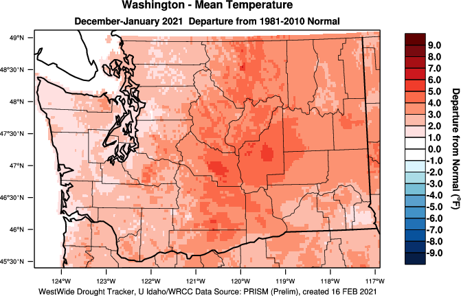
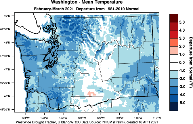
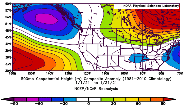
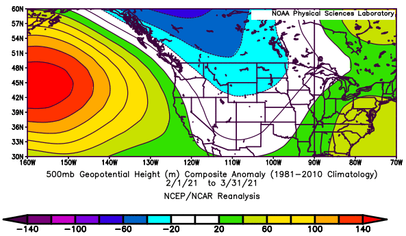
There was also some substantial monthly variability within the winter. Statewide average temperatures were near-normal for October and November with a mix of wet and dry regions. December and January were considerably warmer than normal. Together, the two-month period ranked as the 10th warmest on record, with temperatures ranging between 1 and 5°F above normal (Figure 3). For precipitation, those two months were wetter than normal for most of the state (not shown), so despite the warmth, snowpack was still able to build. The exception was the Lower Columbia Basin, where drier than normal conditions prevailed. A transition occurred near the end of January to below normal temperatures and above normal precipitation with a fairly strong rainshadow effect east of the Cascades. Figure 3 also shows February-March 2021 temperature departure from normal, with temperatures between 1 and 4°F below normal. The near-normal temperatures just east of the Cascade crest are a result of colder than normal February temperatures and warmer than normal March temperatures essentially cancelling each other out for that particular area. As illustrated in Figure 4, the contrast between the relative warmth of the early part of our winter versus its latter portion is associated with a change in the regional circulation. December and January in the mean had anomalous south to south-southwesterly flow aloft over WA, and hence a tendency for a warm source for our air masses. That switched in February, as the anomalous northwesterly flow over WA in February-March favored cooler and wetter conditions, which more typically accompanies La Niña.
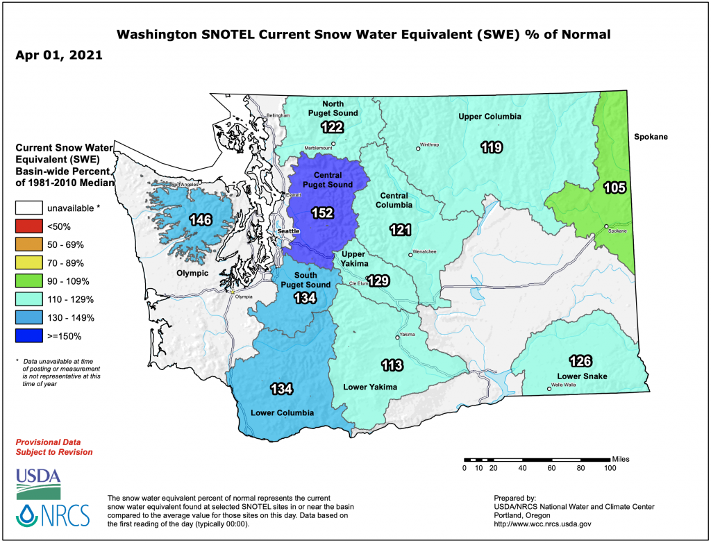
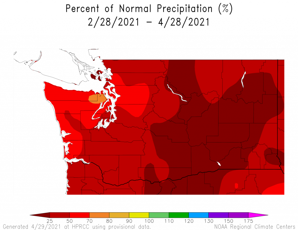
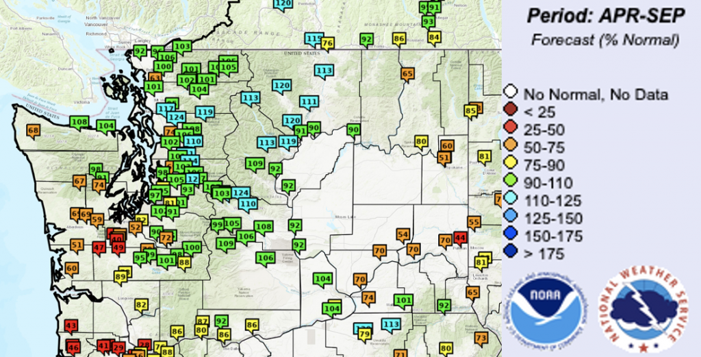
The cooler and wetter pattern that began in February brought huge gains in snowpack in the mountains. By April 1 (Figure 5), snowpack was above normal (119-152% of normal) throughout the Cascade and Olympic Mountains. However, the picture isn’t all completely rosy. March and April were exceptionally dry; March ranked as the 11th driest on record and the two months combined (Figure 6) only received between 5 and 50% of normal precipitation for a majority of the state. March and April are still relatively wet months climatologically, and the precipitation deficits range between 3 and 12” of precipitation for the two months combined. In addition, a warm spell in mid-April caused a period of pronounced melting of our mountain snow around the state. Temperatures in the coming weeks will dictate whether we see early meltout, or whether cooler temperatures cause a more typical meltout curve through May and June. The Apr-Sept streamflow natural forecast as of April 29 indicates below normal streamflow in southwest and southeast WA (Figure 7). Low forecasts that range between 40 and 49% of normal streamflow are shown for the South Fork of the Palouse at Pullman, as well as the Newaukum near Chehalis, and the Chehalis near Centralia, Grand Mound, and Doty. The rivers on the coast and in southwest and southeast WA that have below normal forecasts are primarily rainfed, and are responding to the recent drier than normal weather. The snowmelt driven rivers throughout the Cascades and Olympics have normal to above normal Apr-Sept streamflow predicted.
In summary, our wet season had near-normal temperatures and precipitation, averaged statewide. There was variability though; notably eastern WA had above normal temperatures and the Lower Columbia Basin was both warm and dry relative to normal. The CPC seasonal forecasts for December-February and January-March were right in calling for wetter than normal conditions, on average, though the below normal temperatures did not come into fruition until February, and for the season as a whole, conditions were on the warm side. The dry conditions experienced this spring so far, were also not predicted by the CPC. Both the recent dryness and the Northwest River Forecast Center’s streamflow forecast indicate that conditions will need to be watched closely this spring and summer as some water supply issues may arise. In particular, there may be implications for dryland agriculture in the Lower Columbia Basin, where soil moisture is already low due to long-term dryness.