Review of 2014: Climatic Averages and the Top Weather and Climate Events
Febuary, 2015
With over a month of the New Year already behind us, we would like to review 2014 from a weather and climate perspective. Globally, 2014 ranked as the warmest year on record, but how did it stack up for Washington State? Statewide average temperature and precipitation during 2014 are presented, as well as what OWSC considers the most notable weather and climate events of 2014.
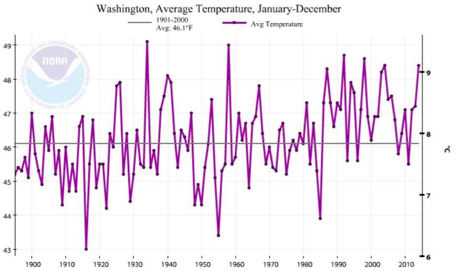
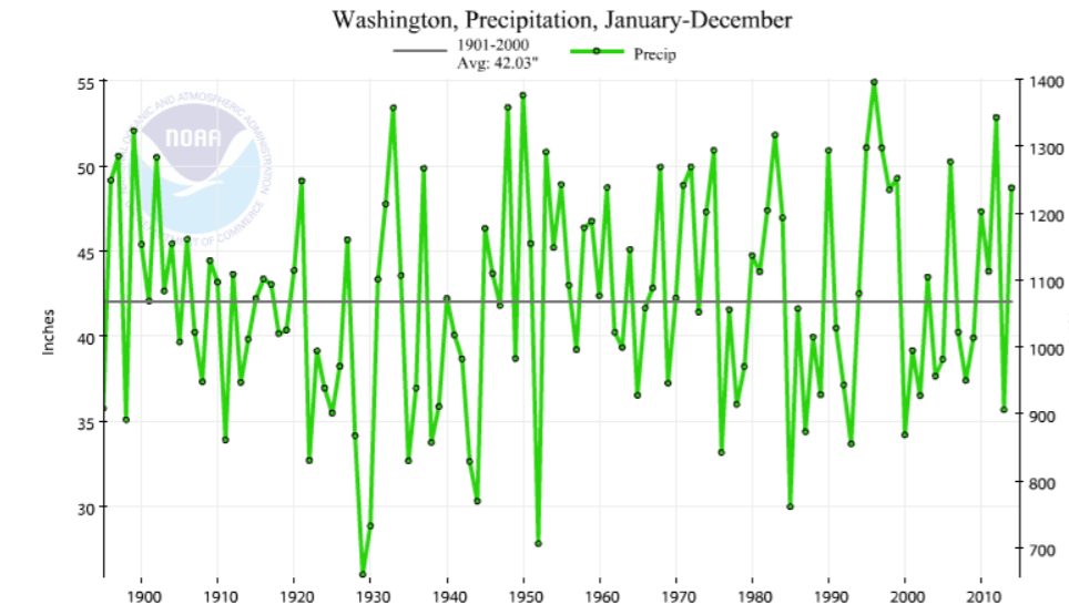
According to the National Climatic Data Center (NCDC), the mean temperature for the state during 2014 was 48.2°F, which is 2.3°F above the 20th century average. This ties 2004 as the 5th warmest year since 1895 (Figure 5). Several recent years have comparable statewide temperatures to 2014, namely 1992, 1998, and 2003, but the record warmest year for WA remains the Dust Bowl year of 1934. Precipitation during 2014 averaged across the state is estimated at 48.73”, which is 6.70” above the 20th century average but still more or less in the middle-ofthe-pack when compared to the historical record (Figure 6). With respect to recent years, 2014 was wetter than 2013, but not as wet as 2012. Of course one size does not fit all, and in particular, the Columbia basin of eastern WA was slightly dry on the heels of the quite arid year of 2013. This resulted in adverse impacts on dryland farming (e.g., wheat yields) and soil moisture levels remain sub-par in this part of the state.
(from NCDC).
The most interesting aspects of the year are often in the details. Here we summarize the top weather and climate events of the year in chronological order.
1). Great Snowpack Comeback Winter – 2013-14 began very dry with low snowpack, leading to concern for the water supply for the following summer. In early February, the basin average percentages of normal snow water equivalent (SWE) were between 51 and 66%. A major shift in the weather pattern occurred in mid-February: heavy precipitation and colder than normal temperatures through the remainder of the month helped the snowpack situation immensely. The growth in snowpack was impressive with SWE throughout much of the Cascades ranging between 92 and 105% of normal by early March. The snow depth on Hurricane Ridge in the Olympic Mountains, for example, doubled from Feb 1 (32”) to Mar 1 (64”). Figure 7 shows the season’s SWE trace at Stampede Pass, with ~20” increase during the month of February.
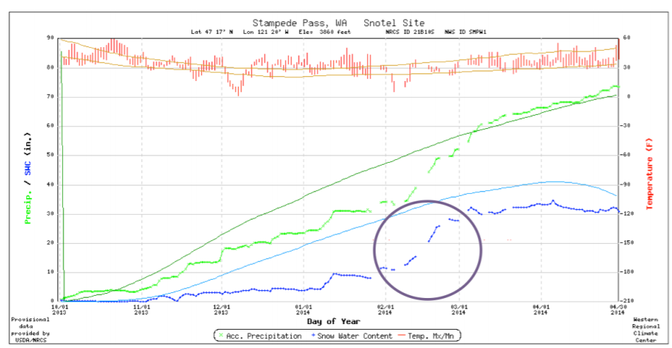
(from NRCS).
2). Wet March & Oso Landslide – The wet period that began in February continued through March, making March notable for the amount of precipitation. Statewide, it ranked as the 6th wettest March since records began in 1895. As an aside, March 2011 and 2012 were both wetter than March 2014 when averaged statewide. March precipitation ranked high among individual stations as well. At SeaTac Airport and the Seattle Weather Forecast Office, it was the wettest March on record with precipitation totals of 9.44 and 8.42”, respectively. Eastern WA also had its fair share of records. March ranked as the second wettest in Colville, the fifth wettest at Mazama, and the sixth wettest at Spokane Airport, for example. March was also the month of the devastating Oso landslide in Snohomish County, which is tragically the deadliest landslide in state history. While the heavy precipitation in the preceding two months was likely a contributing factor in the slide, there is evidence that these deep landslides are a response to conditions and mechanisms acting on much longer time scales. Much more information on the Oso landslide is provided by Keaton et al. (2014).
3). Warm July-September – The summer of 2014 was consistently warm throughout Washington. Averaged statewide, the July through September period was the 3rd warmest on record with an average temperature of 65.2°F, 3.7°F above the 20th century average. Only 1998 and 1967 were warmer by that measure. Figure 8 shows the maximum and minimum temperatures for SeaTac Airport during that time period, where the average temperature was the 2nd warmest on record. It’s worth noting that the maximum temperatures are frequently above normal, but not often near the record maximum (red line). In other words, it lacked many extreme heat events. In terms of minimum temperatures, the statewide average during July through September in 2014 tied the all-time record set in 1998. This was a consistent feature of the summer weather, as illustrated by the record at SeaTac Airport, where it dipped below the average minimum temperature on only about a half-dozen nights (Fig. 8). The balmy nights were at least in part associated with higher than normal humidity, which relates to the next element.
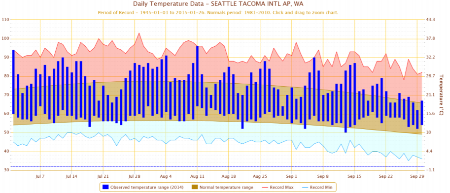
(blue envelope).
4). “The Blob” – The persistent and high-amplitude ridge of high pressure that blocked the usual parade of storms off the ocean into the Pacific NW during the early part of the winter of 2013-14 resulted in suppressed cooling of the upper ocean off our coast. The upper ocean temperatures were more than 3 standard deviations above normal by February 2014, and these waters remained warmer than normal through the remainder of the year. There were noticeable impacts on the marine ecosystem, including relatively low chlorophyll concentrations during the summer of 2014, and many sub-tropical species sighted north of their usual ranges. Some recent research carried out by OWSC has revealed that the low-level temperature and humidity over WA correspond positively with ocean temperatures in the region of the Blob; presumably the latter is partly responsible for the overall warmth we have enjoyed, or endured, depending on one’s point of view, during 2014.
5). Thunderstorms and the Carlton Complex Fire – Thunderstorms on July 14 in north central WA sparked several fires. The four separate fires in the Methow Valley eventually combined and intensified on July 20 and became known as the Carlton Complex fire. The Carlton Complex fire became the largest recorded fire in state history at over 250,000 acres, overtaking the 1902 fire near Yacolt on the west side of the Cascade Mountains. Hundreds of structures were burned, an estimated 1,000 head of cattle were lost, and there was substantial damage to rangeland and orchards. The silver lining in all of this destruction is that authorities worked diligently to evacuate residents in danger, yet a single life was still lost (due to a heart attack while working to save a home from the approaching fire). A state of emergency was declared for this disaster, and with the estimated damage totaling at least $35 million, FEMA assistance was granted. Environmental and ecological impacts from this fire will likely be felt for years to come.
6). Record Warm December Days – Continuing on the “warm” theme, December 10 was a day that set temperature records all around the state. High temperatures rose into the 60s and even the low 70s in some places, which is remarkable for December. In the warm sector of a low pressure system, temperatures reached 71°F in Walla Walla, 67°F in Bellingham, 66°F at SeaTac Airport, and 64°F at Olympia, for example. These temperatures are not only high temperature records for December 10, but are the warmest December temperatures recorded for any day during the month since records began. High minimum temperatures were also recorded, with Pullman and Omak recording 42 and 36°F on the same day. The month was warm as a whole as well, ranking as the warmest December on record for SeaTac AP and Quillayute, and ranking among the top ten warmest for other stations around the state.
This is a brief summary of an eventful year in terms of the weather and climate, and is not comprehensive. Warm temperatures were definitely a hallmark of the year, with December and the summer standing out, as well as warm temperatures for the year as a whole. Historic events occurred, with the largest fire and the deadliest landslide marking it as a year for tragedy. On a more positive note, there were record harvests of apples (about 150 million cartons versus 128 million cartons during the previous top year of 2013) and wine grapes. Indications are that the quality of the grapes was also high, which is good news for this increasingly important crop in WA State.