Review of 2013: Climatic Averages and the Top 6 Weather and Climate Events
February, 2014
With 2013 now in the books, we would like to review the year from a weather and climate perspective. First, the Washington State average temperature and precipitation during 2013 are presented, along with a comparison to other years. Second, we will review what OWSC considers the top 6 notable weather and climate events of 2013.
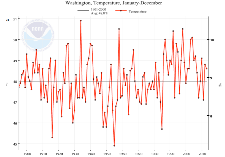
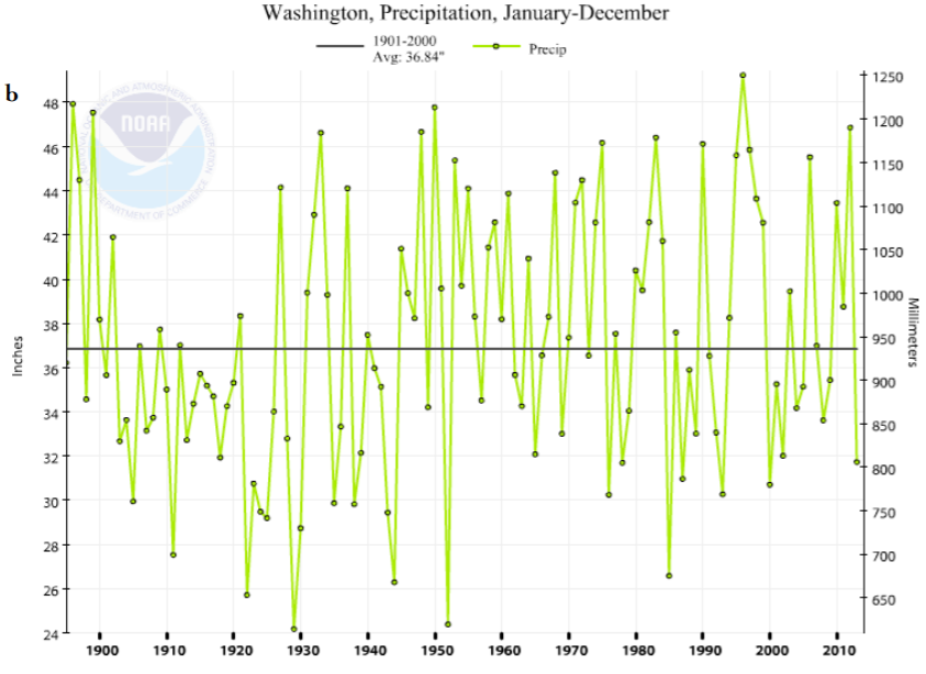
According to the National Climatic Data Center (NCDC), the mean temperature for the state during 2013 was 48.6°F, which is 0.6°F above the 20th century average. Figure 1a shows the temperature time series for WA since 1895 from NCDC. The time series indicates that the mean WA temperature during 2013 was similar (0.2°F cooler) to the 2012 average temperature. On the other hand, the statewide precipitation during 2013 was much different than that during the previous year (Figure 1b). The total precipitation for 2013 averaged across the state is estimated to have been 31.72”, which represents a value that is 5.12 inches below normal. It ranks as the 20th driest year in the record extending back to 1895. The precipitation during 2012 was much greater than normal (10.03” above the 20th century average), ranking as the 5th wettest year in the record.
The most interesting aspects of the year are often in the details. Here we summarize the top 6 weather and climate events of the year in chronological order. Note that our list lacks entries for the period between January and July. The absence of notable weather during that period is itself remarkable, and could potentially be on the list! Instead, here we’ll focus on the more active events.
1) Warm August Overnight Temperatures – Minimum temperatures around the state were higher than normal during much of the summer and especially during August. These elevated temperatures resulted in monthly minimum temperatures ranking as the warmest on record for several western WA locations (e.g., Quillayute (54.5°F), SeaTac (59.9°F), and Boeing Field (61.5°F)), and among the top ten for stations around the whole state (e.g., Spokane Airport (59.4°F) and Walla Walla (63.6°F)). Seattle Boeing Field checked in with 22 days in August with overnight temperatures greater than 60°F. As an aside, the month also featured high humidity and enhanced thunderstorms, especially in eastern WA. Thunderstorms caused flash flooding from heavy rain, hail, high winds, downed power lines, etc., that totaled an estimated $1.6 million in property damage, mainly on the east slopes of the Cascades through central WA.
2) Wet September – This month ranked as the wettest September for WA as a whole (3.25” above the 20th century average) and for many individual stations in western and north central WA (e.g., Olympia (9.36”), SeaTac Airport (6.17”), Stehekin (5.02”), and Leavenworth (4.04”)). The wet conditions were mostly due to an intense, long-lasting batch of thunderstorms on September 4-6, and an unusually wet and windy extratropical storm for early in the rainy season at the end of the month (Sept 28-29). About $1.3 million in property damage occurred in Chelan, Douglas, and Okanogan counties due to effects of thunderstorms on Sept 5.
3) EF1 Tornado in Western WA – On September 30, an EF1 tornado touched down near Frederickson (southeast of Tacoma in Pierce County) as a part of a larger system that brought heavy rain to the state. The tornado left a damage path of about 1 mile long and 75 yards wide. Thankfully, no injuries were reported with this tornado, but about $25,000 worth of property losses were reported (including roof damage, downed trees, vehicle damage, downed lamp posts, and tipped empty rail boxes) with winds estimated at 110 mph. Tornadoes in western WA are rare to begin with, and occur most frequently in spring, so this event in September is notable.
4) October Dominant High Pressure Ridge – A ridge of high pressure at upper levels dominated the regional circulation during October (13-26), resulting in a temperature inversion that brought persistent fog and cold temperatures to lower elevations, and sunny skies in the mountains. While October is the month in which fog is most common in western WA, this period of fog was relentless. Olympia recorded 24 days with heavy fog (defined as visibilities less than a quarter mile) during the month when 11 days are typical. SeaTac Airport recorded 12 days of heavy fog (normal is 4 days) and Spokane Airport recorded 9 days of heavy fog (normal is 3 days). The ridge also caused a dry spell; there were 14 consecutive days without even a trace of precipitation measured at SeaTac – relatively rare for October.
5) December Cold Snap – Cold temperatures gripped the state for about a week in December (Dec 3-10) and broke daily low temperature records around the state. Low temperatures were in the single digits and even negatives in eastern WA and in the teens and 20s in western WA. The temperatures during this cold stretch were the coldest experienced in WA State since February 2011, and were that much more impressive considering there was limited snow on the ground.
6) Dry Fall – The period from October 1 through December 31 was extremely dry. In quantitative terms, the statewide average precipitation was 7.44 inches, which is only about 52% of normal. This ranks as the second-driest Oct-Dec on record, behind 1976. The Oct-Dec period was among the driest when compared to individual station records as well. For example, SeaTac Airport, Hoquiam, Olympia, Vancouver, and Wenatchee all recorded their second-driest Oct-Dec since records began at each stations, and the period is within the top 5 driest at others such as Walla Walla, Spokane Airport, Omak, and Yakima. Despite the lack of major floods (and wind storms) throughout 2013, there are still interesting temporal variations in precipitation, mainly on longer time scales, that characterize the year. Overall, the dry conditions, both for the beginning of the year (Jan-Mar), the end of the year (Oct-Dec), and the year as a whole are the most notable. Figure 2 shows the accumulated precipitation over the course of 2013 for SeaTac Airport and Spokane Airport, and these dry stretches are clear. The wettest times of the year were the shoulder months of April (western WA), June (eastern WA), and September (both), also highlighted in Figure 2.
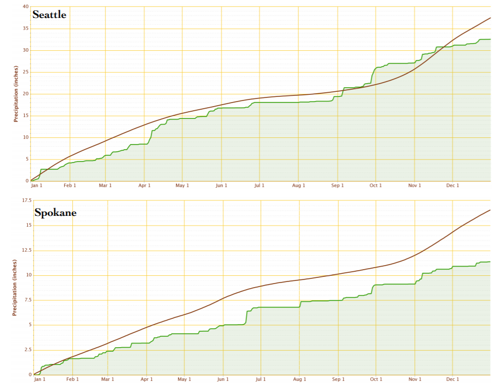
Spokane Airport (bottom). The smoothed line is 1981-2010 normal precipitation.