A Review of Winter 2013-2014
4/22/2014
The predictions for the winter of 2013-14 included little consensus among the seasonal forecast models in August and September, but were hinting at dry winter conditions by October 2013. However, neutral El Niño-Southern Oscillation (ENSO) conditions were projected for the upcoming winter, resulting in a lack of a strong statistical signal toward below or above average temperature or precipitation anomalies for the winter as a whole. So how did the winter play out? This report summarizes the winter ENSO conditions, snowpack, average temperature and precipitation anomalies for Washington State, and the seasonal variations in weather.
Figure 1 shows the sea surface temperature (SST) anomalies from January 2006 through February 2014 in the Niño 3.4 region of the equatorial Pacific Ocean. While SSTs were a bit on the cool side for winter 2013-14, the anomalies were not strong enough to be classified as a La Niña event. For two winters in a row, the ENSO signal has been neutral. It is worth noting that the ENSO forecast models were accurately predicting neutral conditions well in advance, as opposed to last winter (2012-13), where models were split between neutral and weak El Niño states.
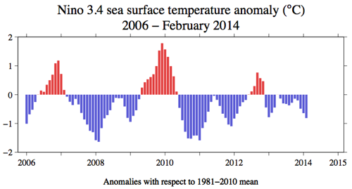
Figure 1: SST anomalies from January 2006 through February 2014 in the Niño 3.4 region of the tropical Pacific (figure by Todd Mitchell). Please click on the figure to see the full-size image.
Neutral ENSO conditions do not provide a systematic signal in the temperature and precipitation anomalies for the PNW compared to either an El Niño or La Niña event, so how did this year shape up? Figure 2 shows the mean October through March temperatures compared to the 1981-2010 normal for the entire U.S. Temperatures were below normal (between 1 and 2 degrees Fahrenheit) for eastern WA and the Puget Sound region. Elsewhere in the state – the Olympic Peninsula, southwest WA, and the Cascades – temperatures were near-normal (within 1 degree Fahrenheit). Winter precipitation (Figure 3) was generally below normal, especially in western WA where precipitation deficits ranged between 3 and 18 inches. The deficit in northeastern WA was between 3 and 6 inches while the rest of eastern WA had within 3 inches of normal winter precipitation, though mostly on the drier side.
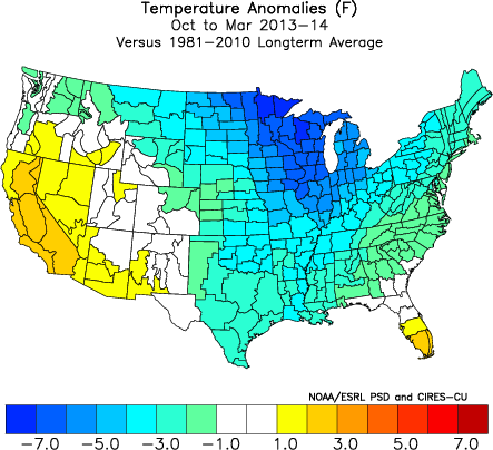
Figure 2: Oct-Mar 2013-2014 temperature anomalies (Fahrenheit) from the 1981-2010 normal (from ESRL).
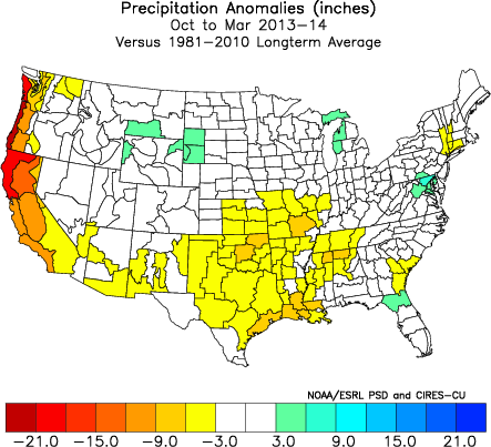
Figure 3: As in Fig. 2, but for precipitation (inches) (from ESRL).
The average winter conditions provide one perspective on the past winter, but it is also worthwhile to consider the progression of the weather over the course of the season. October got the 2014 water year off to a very dry start; a persistent high pressure that settled to our west caused frequent fog, cooler than normal temperatures, and also blocked our typical storm systems from bringing precipitation to the state. November, December, and January were all drier than normal. Averaged statewide, the October through January period ranked as the 6th driest Oct-Jan on record, with total precipitation 8″ below the 20th century long-term average. On the other hand, the temperature anomalies for that period were not as consistent. While mean November temperatures were near-normal, average December temperatures were colder than normal, thanks in part to a statewide cold air outbreak that occurred in the beginning of the month. Temperatures during the cold spell were the coldest that many parts of the state had seen in several years. On the other hand, mean January temperatures were warmer than normal. A change in the precipitation anomalies occurred in February; total monthly precipitation was greater than normal during both February and March. Total precipitation averaged statewide for March ranked as the 6th wettest since records began in 1895. Mean monthly February temperatures were much colder than normal and March temperatures were near normal.
The dipole nature of the precipitation anomalies throughout the past winter caused concerns for drought early in the season. The WA State Department of Ecology convened the Water Supply Availability Committee (WSAC) in early February for the first time since early 2010. Figure 4 shows the average basin snow water equivalent percent of normal throughout WA as of 4 February. The snowpack was below normal nearly everywhere in the state at that time, and the Olympic Mountains and the southern WA Cascades were the worst off, with a basin average of 33% of normal in the Olympic Mountains and 49% of normal in the western slopes of the south WA Cascades. Copious rains and mountain snows accompanied the change in the weather pattern during the second week of February causing remarkable comebacks in snowpack. Snow depth on Hurricane Ridge in the Olympic Mountains, one of the regions that caused a lot of early concern, doubled from 32″ on 1 Feb to 64″ on 1 Mar. As of 1 April, snowpack throughout WA State is near normal to above normal, except for the Olympic and Lower Columbia basins, where the basin average SWE is 83 and 88% of normal, respectively (Figure 5). The improved snowpack has aided in a favorable summer water supply forecast. The National Weather Service Northwest River Forecast Center April through September water supply forecast (Figure 6) projects normal (90-110% of normal), greater than normal (110-125% of normal), and even much greater than normal (125-150% of normal) streamflow for most of the state. A few rivers in the Olympics and the south Cascades where snowpack is lower than normal are projected to have slightly below normal (75-90% of normal; Cowlitz at Castle Rock and the Dungeness near Sequim) or below normal (50-75% of normal; Lewis – Merwin Dam) streamflow through September.
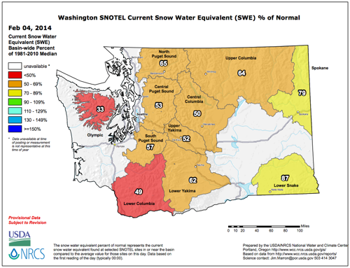
Figure 4: Snowpack (in terms of snow water equivalent) percent of normal for WA as of 4 February 2014 (from NRCS). Please click on the figure to see the full-size image.
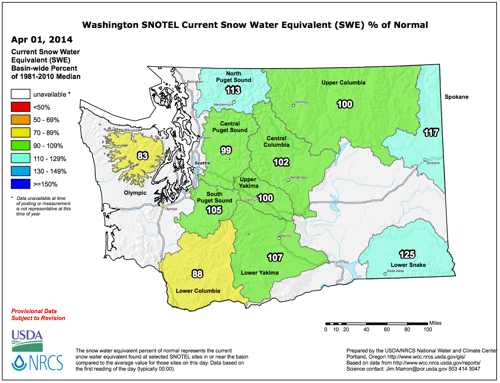
Figure 5: As in Figure 4, except as of 1 April 2014 (from NRCS). Please click on the figure to see the full-size image.
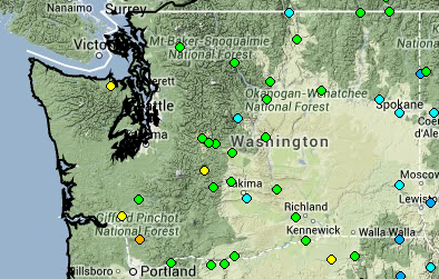
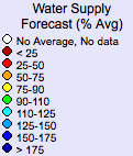
Figure 6: April through September 2014 water supply forecast for WA as of 3 April 2014 from the National Weather Service River Forecast Center.
In summary, winter 2013-14 was considerably drier than normal with near-normal to below normal temperatures. Neutral ENSO conditions were predicted early, and that forecast came into fruition. More than half of the winter was marked by very dry weather and lagging snowpack, but was compensated by a wet February and March. There is some remaining concern for parts of eastern WA in the rainshadow of the Cascade Mountains, especially in regards to the impact on dry land agriculture for the upcoming fall. The situation will continue to be monitored on the state level. Currently, there are increased chances for an El Niño to develop for next winter; stay tuned for more reliable forecasts by the middle of summer.
How to meet a girl on social networks. 3. Monitor your online behavior. Post posts about your recent breakup with your ex? Posting pictures about how skipthegames capecod all women are bitches? Being rude in the comments? Then don’t be surprised if your posts go unanswered. 4. Honor literacy. If punctuality is the courtesy of kings, then literacy is the courtesy of Internet users. It’s also the first indication that you have a developed intellect.
