July 2009 Heat Wave
8/3/2009
Parts of Washington, and in particular western WA, felt the heat during the last week of July. A heat wave gripped the state on Monday, July 27 and lasted through Thursday, July 30. Highs in western WA reached into the 90’s and 100’s, and daily records as well as all-time records were broken.
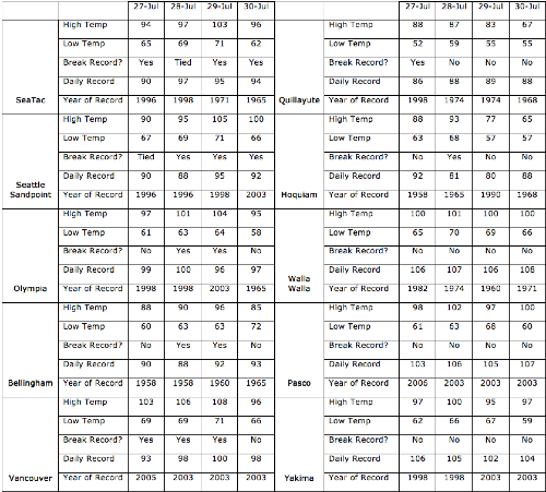
High temperatures in the 90’s were experienced in western WA on July 27, with SeaTac’s high of 94 degrees F, Quillayute’s high of 88 degrees F, and Vancouver’s high of 103 degrees F all breaking the daily record (Table 1). More daily records were tied or broken on Tuesday (July 28), including SeaTac’s high of 97 degrees F, Olympia’s high of 101 degrees F, Vancouver’s high of 106 degrees F, and Hoquiam’s high of 93 degrees F (Table 1). Perhaps even more impressive was the inability of the temperatures to cool down at night. The low temperature for July 28 at SeaTac was only 69 degrees F, tying the highest minimum temperature recorded at any time of the year. It hasn’t been that warm at night since September 2, 1974 nor at any other time since records began in 1948 at SeaTac.
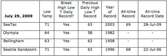
More all-time records were broken on Wednesday, July 29. The minimum temperature was even higher than the previous day at SeaTac, breaking the all-time record for highest minimum temperature. The record for highest minimum temperature at SeaTac is now 71 degrees F. Another station in Seattle (Seattle Sandpoint) broke its all-time record for highest minimum temperature that was previously set on July 22, 2006. The minimum temperature was only 71 at Seattle Sandpoint on July 29 of this year. Olympia and Bellingham had high minimum temperatures on July 29 as well, breaking daily records, but not all-time records (Table 2).
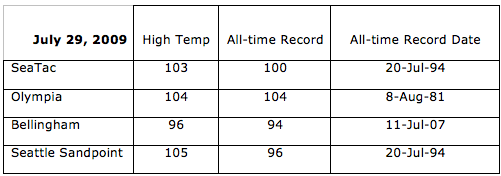
In addition to the high minimum temperature, July 29 had extraordinarily high maximum temperatures as well. SeaTac, Bellingham, and Seattle Sandpoint all broke records for the highest temperature recorded on any day at any time of the year (103, 96, and 105 degrees F respectively). Olympia tied its all-time record, with the temperature reaching up to 104 degrees F (Table 3). The last time the temperature was that high in Olympia was August 8, 1981. Vancouver had a high of 108 degrees F on July 29 shattering the daily record (Table 1).
Conditions were eased in some locations on July 29: Hoquiam was a comfortable 77 degrees F and Quillayute was 83 degrees F as some marine air pushed through to the coast. On July 29, locations west of the Cascades were warmer than places east of the Cascades that are more accustomed to this kind of heat. Pasco, Walla Walla, and Yakima were 97, 100, and 95 degrees F on July 29, none of which broke daily records (Table 3). Throughout the entire heat wave, parts of the Yakima Region had temperatures that were higher than normal, but they did not break daily records, and temperatures that high are periodically experienced through the summer in the region. Temperatures in the Yakima Region reached the upper 90’s on July 27, with Walla Walla reaching 100 degrees Fahrenheit. On July 28, parts of eastern WA reached into the triple digits (Table 1). The high temperatures in western WA were more unusual.
By July 30, coastal locations were at normal temperatures: Hoquiam’s high temperature was 65 degrees F and Quillayute’s was 67 degrees F. Through the interior of western WA, high temperatures persisted into the 90’s, however, and Seattle Sandpoint even reached 100. Two daily records were broken (SeaTac and Seattle Sandpoint), but other locations were just shy of breaking daily records set in 1965 (Table 1).
The atmosphere was set up well for an extended heat wave in western WA: there was a high pressure to our east, warm air aloft, a strong, stationary upper level ridge, high dewpoint temperatures, and easterly flow at the surface. Winds from the east meant that there was downslope warming over the Cascades, making and keeping our temperatures warm. It also inhibited relief from westerly ocean air. In addition, the relatively high dewpoint temperatures (especially for our region) made it feel more humid than usual and kept it warm at night. Relief came from marine air that moved in on Thursday evening (July 30), bringing cooler overnight temperatures. The air from the ocean brought thick, stratus clouds throughout western WA on Friday morning (July 31), but clearing occurred and the high temperatures in the interior of western WA were still about 5-10 degrees F above normal (in the mid to upper 80’s). The weekend was warm as well with high temperatures above normal and even a few daily records broken (i.e. Seattle Sandpoint reached 91 on Aug 2), but it offered some sense of relief from the all-time record high temperatures.
How does this heat wave stack up to others? At SeaTac, there were 4 consecutive days above 90 degrees F (July 27-31). This is the fifth occurrence of 4 consecutive days above 90 at SeaTac. The other periods are July 21-24, 2006; July 16-19, 1979; August 9-12, 1977; and August 8-11, 1971 with 4 consecutive days above 90 degrees F. The record is 5 consecutive days above 90 that occurred from August 7-11, 1981 and July 14-18, 1941 and it remains in tact. SeaTac has had 6 consecutive days (July 25-30) with high temperatures above 85 degrees F. The record is 9 days and, with the cooler day on July 31 (high of 84 degrees F at SecTac), the previous record remains in tact. The 3 consecutive days at SeaTac with low temperatures greater than or equal to 65 degrees F (July 27-29) was also close to record-setting. There have been 4 consecutive days with low temperatures above or equal to 65 (July 21-24, 2006) and one other time when there’s been 3 consecutive days (August 9-11, 1981). This heat wave is the first time in SeaTac’s history (since 1948) that there has been 3 consecutive days with high temperatures above 95, however (July 28-30). There were 2 consecutive days with highs above 95 on July 21-22, 2006, August 9-10, 1981, July 16-17, 1979, and August 8-9, 1960 at SeaTac. The stats in this paragraph only include SeaTac’s record which began in 1948.
Records were in jeopardy at other stations as well. At Olympia, this heat wave tied the 2nd most consecutive days with temperatures greater than or equal to 95. There have been 4 consecutive days with high temperatures greater than or equal to 95 (July 27-30) since 1948 and that has also happened on July 21-24, 2006 and on July 29-August 1, 1965. The all-time record of consecutive days above 95 at Olympia is 5 days and that occurred on August 7-11, 1981. In Vancouver, there were 3 consecutive days with high temperatures above 100 degrees F during this heat wave (July 27-29). While this did not break the record of 4 days (occurring July 13-16, 1941), it does rank 2nd along with three other periods. There were 4 consecutive days with low temperatures greater than 65 degrees F during this heat wave at Vancouver (July 27-30). This does not break the record (5 days on July 14-18, 1941), but ranks second along with 1 other period. The records at Vancouver started in 1896.
Finally, the month of July was one of the warmest on record. In Seattle (SeaTac records plus the Federal Building – starting in 1891), the average temperature was 69. 5 degrees F. This is tied for the warmest average temperature for July. The other July with an average temperature of 69.5 degrees F occurred in 1941 at the Federal building in downtown Seattle. The average temperature of 69.5 ranks July 2009 and July 1941 as the second warmest month (not just July) on record. The warmest month was 71.1 degrees F in August 1967. The average high temperature for July 2009 was 81.0 degrees F, ranking as the 2nd warmest July on record (since 1891). July 1958 was warmer, with an average high temperature of 81.4 degrees F. Finally, July 2009 is only the 7th month with an average high temperature of 80 degrees F or greater in Seattle history. Other months with the average high temperature at 80 or above are August 1967, July 1958, July 1985, August 1961, August 1986, and July 1941. In Olympia, the average July temperature was 66.8 degrees F, ranking as the 3rd warmest July on record. In Bellingham, the average July temperature was 65.4 degrees F, ranking as the 4th warmest on record.
Please remember that a single event cannot be attributed to climate change. Attribution studies and methods are getting better, but it’s too soon to pin down any one event to climate change. Just like a cold spell does not disprove global warming, a heat wave does not prove it either. Please see our January 2009 newsletter for a discussion of this.
This summary will be updated as more information becomes available.

Table 1: High and low temperatures (degrees F) for selected Washington locations during the July 2009 heat wave. Daily records are also listed, and there is a column confirming whether or not the 2009 temperature broke the record for that day. (Please click on the image to view it larger).

Table 2: Low temperatures (degrees F) for western WA locations on July 29, 2009. Records were broken for both the highest minimum temperature on that specific day, and the all-time record for highest minimum temperature on any day on any time of the year.

Table 3: All-time high temperature (degrees F) records that were tied or broken on July 29, 2009, along with the previously held record.
