1954 – The Year Without a Summer
The summer of 2016 in WA state has had kind of a dual personality. From the middle of June into August, near to slightly below normal temperatures mostly prevailed during the part of the year that is typically the warmest. These pleasant conditions were bracketed by some periods of quite warm weather during spring and the second half of August. While the nearnormal mid-summer temperatures in WA certainly were not extreme, here we focus on what type of pattern does bring extreme, abnormally cool or wet weather in the summer.
The year of 1954 had the coolest summer (June through August) for WA in the observational record going back to 1895. The statewide average temperature anomaly was -3.4°F compared to the 1901-2000 normal. The summer of 1954 also brought a prolonged and intense heat wave to the Midwest region of the United States. An inverse relationship between the two regions is no coincidence; large anomalies of one sense around here are generally associated with a major perturbation in the large-scale atmospheric circulation that also produces temperature anomalies of the opposite sense a couple of thousand kilometers away. The objectives of this piece are to illustrate the daily temperatures during the summer of 1954 and how the regional circulation for the summer as a whole compares with that of 1983, which was the wettest on record but not particularly cool.
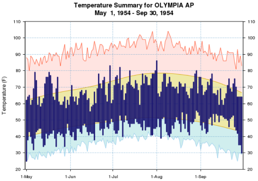
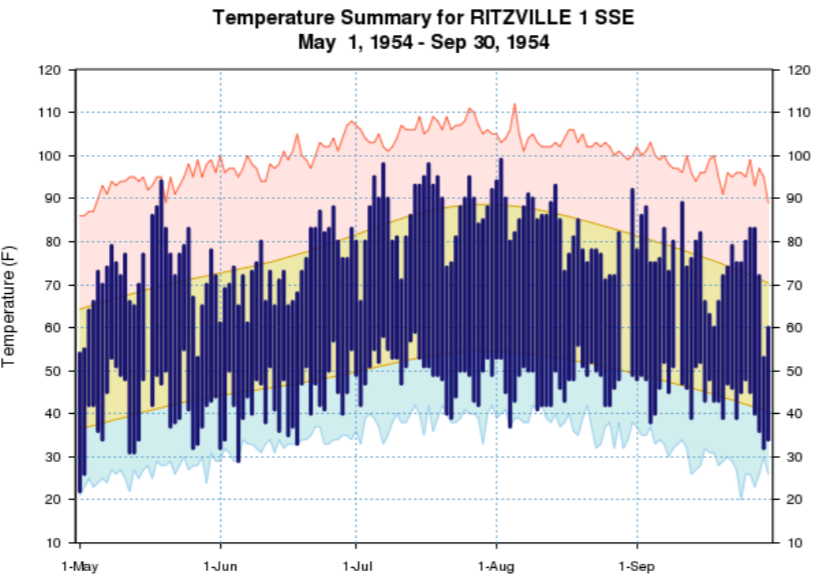
Time series of daily maximum and minimum temperatures for May-September 1954 (a month was added on each side to show what it was like going in and coming out of summer) are presented for the western WA location of Olympia and the eastern WA location of Ritzville in Figures 1 and 2. There were some occasional warm days, especially in Ritzville, but consistently cool nights. At both locations, nighttime temperatures dipped down to the low 40s or below on multiple occasions, and during the period of June through August daily record lows were set 3 times in Olympia and 5 times in Ritzville. These low minimum temperatures undoubtedly helped push 1954 to the number one spot. Another recent year – 1993 – had a similar negative anomaly in magnitude for the maximum temperatures but had exactly normal minimum temperatures. As a result, 1993 was tied for the 4th coolest summer on record in terms of average temperatures.
As for summer precipitation, it was relatively wet in 1954, with a statewide average precipitation total for the period of June through August of 6.00”. This amount is 2.20” greater than the 20th century normal and the 7th greatest on record. But it rained a fair amount more in the record wet summer 1983, with a positive anomaly of 3.38”. With respect to statewide average temperature, 1983 was only 0.9°F cooler than the 20th century normal. So what’s the difference between a record cool summer and a record wet summer in WA state?
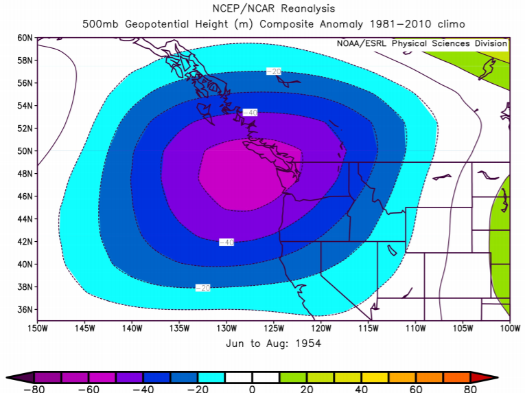
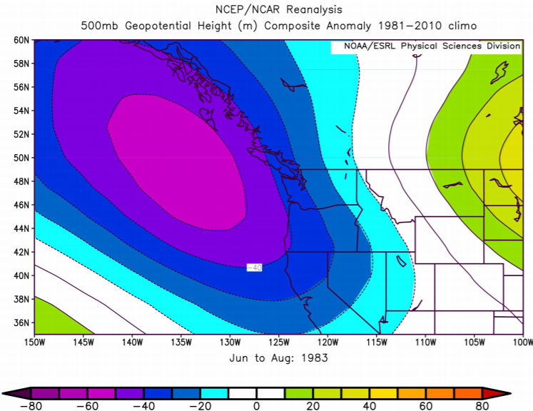
The regional atmospheric circulation was different during the especially cool summer of 1954 than during the wettest summer of 1983. As usual, we use 500 hPa geopotential height (Z) anomaly maps to contrast the two periods. The map for 1954 (Fig. 3) shows a substantial negative anomaly centered over the ocean south of Vancouver Island in a pattern producing anomalous flow from the southwest for WA. This situation favors the landfall of short-wave weather disturbances of North Pacific origin. During the summer these systems tend to be weaker and track farther north than during the winter, but bring plenty of clouds and often some rain to the Pacific Northwest. The 500 hPa map for 1983 (Fig. 4) includes smaller negative Z anomalies over WA and anomalous flow from the southeast. This pattern implies not as strong of a marine influence as in 1954, and instead the Great Basin as a source region to a greater extent than usual. The dregs of monsoonal moisture from the Great Basin can result in significant precipitation in WA state during the summer, especially east of the Cascades, and presumably that happened more than usual in 1983.
Are cool, and for that matter, warm summers just a fluke or are they connected to large-scale modes of the global climate system in a systematic, physically-consistent sense? Are these sorts of situations predictable? Is it possible for mean minimum temperatures in the present and future climate to be as cool as they were in 1954? The variability of seasonal weather conditions in the Pacific Northwest during winter has garnered a great deal more attention than that during summer but maybe that should not so much remain the case.