January 1953: Largest Positive Monthly Temperature Anomaly in WA State History
Considering statewide averages, what would constitute a large monthly anomaly in temperature? And would we expect to see the largest monthly anomaly in winter or summer? At OWSC, these are the sorts of questions that we ask ourselves as we begin a new calendar year. January 1953 takes the top spot in terms of the largest monthly warm anomaly of any month on record (since 1895), checking in with a hefty 8.8°F above normal (1901-2000) across WA state. In second place is a month that might be easier to recall for many of our readers – June 2015 – which was 7.8°F above the 20th century normal. But for this summary, we’ll focus on the monthly weather of January 1953.
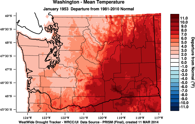
The January 1953 monthly average temperature departures from normal (using 1981-2010) are shown in Figure 1a, indicating warmer than normal temperatures for the entire state. Anomalies were much larger in eastern WA, where monthly temperatures were between 6 and 10°F above normal. Spokane Airport, for example, did not have a single day during January 1953 in which average daily temperatures were below normal. High temperatures were remarkably consistent across the state, with 40s and even 50s common.
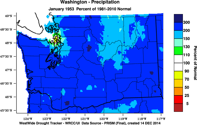
The month was also a wet one. Figure 1b shows the percent of normal (1981-2010) precipitation for January 1953. The month ranks as WA state’s wettest January on record (since 1895) with 14.09”, about 8” above normal. A majority of the state received about double the usual amount of precipitation for the month. We dug up records from the Seattle downtown station, where 27 of the 31 days in the month included measurable precipitation.
It was also a very cloudy month. The same Seattle downtown station reported a gloomy total of only about 11 hours of sunshine for the entire month, with many of the daily entries indicating only 10 or 15 minutes when the clouds parted at all. Of course we expect January to be a cloudy month anyway, but that was especially the case in 1953, for which the 11 hours represents about 10% of normal sunshine. Spokane, in comparison, had about 40% of its normal duration of sunshine.
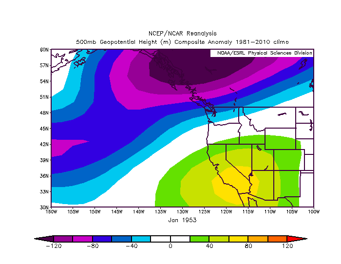
All of these observations are consistent with what the 500 hPa geopotential height anomaly map shows for the month (Figure 2). The month featured anomalous flow from the southwest and hence a much greater import than usual of balmy air masses originating from the subtropical northeast Pacific. Not surprisingly, this was a poor recipe for mountain snow, with both January snow water equivalent (SWE) and end of season SWE below normal that year.
The 1950s were generally a cool decade throughout the Pacific Northwest, and include many of our cold and snow records on various time scales. But, as shown here with the January 1953 warm anomaly, large fluctuations can occur within an overall long-term tendency. The winter of 1952-53 included a weak El Niño as well, which likely played a role in the warmer than normal temperatures experienced that January. Fortunately, your current state climatologists were not around (as in not yet born) to suffer through the unremitting gray skies, copious rains, and amazingly mild temperatures that prevailed during that historic month.