Top 10 Weather and Climate Events of 2019
7/6/2020
In a reprise of previous lists of this sort, here we review the top weather and climate events in WA state for the year of 2019. To be sure, we are halfway through 2020, but hopefully these events are not yet into the dustbin of history and their mention here will bring back some memories, fond or otherwise.
#10 Thunderstorm of 7 September – The early evening of 7 September featured an estimated 2200 lightning strikes in the Puget Sound region accompanied by torrential rain. The storm moved over Seattle during a University of Washington home football game, necessitating a 2+ hour delay in the game while participants and attendees took shelter.
#9 Dust devil of 1 May – While dust devils would seem to be at the low end of the meteorological Richter scale, what must have been a particularly intense example occurred in Zillah, WA on 1 May 2019. It lifted up an occupied “bounce house” and tossed it over 200 feet, leading to 5 children being injured, one critically. About as fluky as it gets in terms of the weather posing a hazard.
#8 Heavy rains in western WA in late December – Skies really opened up on 20 December with numerous stations in Puget Sound region receiving 24-h totals of about 3” (including Sea-Tac with 3.25”). Even greater downpours on the west flank of the Cascade Mountains resulted in widespread flooding. The Snoqualmie River at Carnation, for example, had streamflows about 10 times greater than usual for this high flow time of year.
#7 Lack of snow in Cascades late in the calendar year – Winter sports enthusiasts must have been quite antsy. There was a fair amount of precipitation at times (see item above) but not much snow. On 1 January 2020, snow water equivalent (SWE) totals around the state were typically on the order of 40 to 60% of normal, with particularly low values for the lower Columbia basin including a portion of southwest WA.
#6 Snow near Spokane 26 November – While there was a deficit of snow in the mountains, there was still some wintry weather at times in various locations in WA state. A sudden snow squall just west of Spokane led to a slippery roadway and lack of visibility that resulted in 35 crashes involving 127(!) vehicles on I90.
#5 Early season snow in Spokane – Speaking of snow in the vicinity of Spokane, some heavy and wet snow fell on 28 September, which is remarkably early in the cool season for that area. Broken tree limbs resulted in power outages. Mother Nature delivered a second, stronger punch on 8 October with localized intense snow showers and even more power outages. It was enough of a disruption for the Spokane Public School System to call a snow day for 9 October.
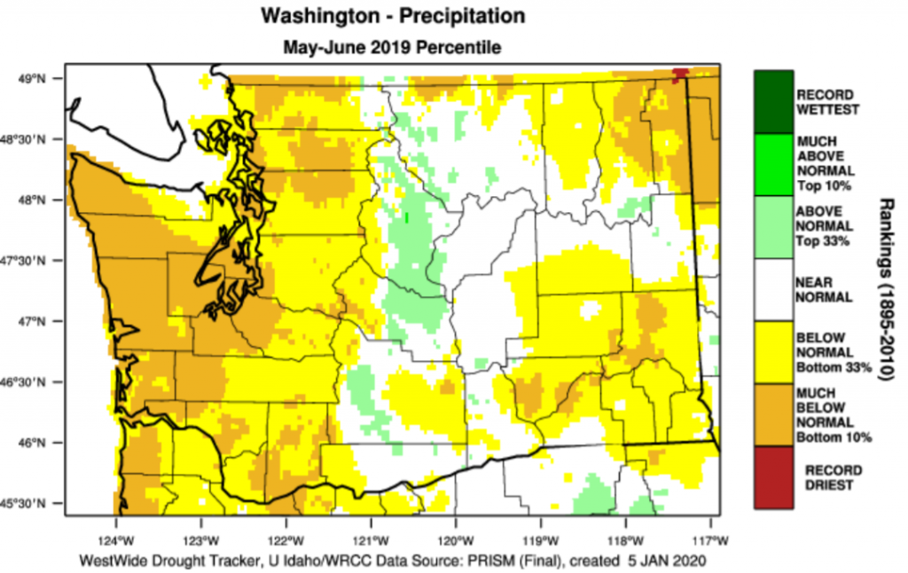
#4 Spring/Early Summer drought – We have had some quite warm springs in recent years. It is evident that even with healthy mountain snowpacks at the end of winter, a warm spring can cause that snow to melt faster than usual, leading to streamflow deficits in summer. The year of 2019 represents an example, with May and June combined checking in with a statewide temperature that was the 7th highest in the entire record, specifically 2.3 °F greater than the 1981-2010 mean. It was also generally drier than normal, especially in the western part of the state, where many locations had precipitation totals that were in the bottom 10%.
#3 Flash flood in Pullman 9 April – A multi-day period of copious rains in southeast WA resulted in flash flooding that inundated the business district of North Grand Avenue in Pullman with up to 4 feet of water. This caused flooding of businesses, parked cars to float away and required water rescues of stranded people. The property damage tab totaled about 1.1 million dollars, but thankfully there were no injuries.
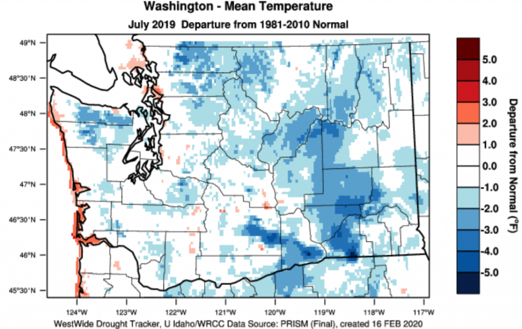
#2 Mild temperatures and quiet wildfire season summer – The residents of WA state experienced relatively smoky summers in 2017 and 2018, and given the rapid drying of the landscape in late spring 2019, some of us feared a repeat. Instead, the summer was noticeably milder and damper than in recent years. While August 2019 was on the warm side, the months of July, and September were 0.9 °F and 0.7 °F cooler than normal, respectively, relative to 1981-2010 averages. Seattle and Spokane had only 2 and 11 days of 90+ °F maximum temperatures, which is about one-half their usual annual totals this century. An important upshot was that only about 170,000 acres burned in wildfires in 2019, as compared with an average of about 530,000 acres during the years of 2014-2018, which was a particularly bad period for fires in the Pacific NW.
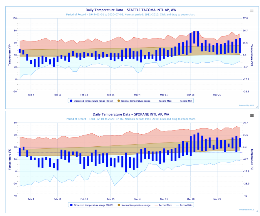
#1 Cold and snow statewide in February extending into March – The winter of 2018-19 got off to a slow start, with statewide temperature anomalies of +3.0 °F in December 2018 and +2.5 °F in January 2019. Given the weak-moderate El Nino in place at the end of January, which tilts the odds towards warmer than normal temperatures in the Pacific NW, fans of wintry weather around here must have been discouraged. But then came February. The cold arrived right after the beginning of the month and stuck around not just through February but also well into March without relief, as shown in the time series of daily temperatures in Seattle and Spokane plotted below. Early March was particularly cold in the Columbia basin portion of eastern WA. We are unsure what is more striking, the statewide anomaly of -9.2 °F for February, or the -6.5 °F anomaly for February and March combined. We have not had a late winter so frigid since 1956. Plenty of snow accompanied the cold, with all sorts of impacts, including the deaths of at least 1600 dairy cows in the Yakima area on 12 February 2019. A much more complete account of this amazing stretch of cold weather is in the March and April 2019 editions of this newsletter.
Why can the doctor refuse to use the drug, which the patient bought. Mikhail Skryabin, oncologist and chemotherapist at the KSPC, graduate of the Higher School of Oncology. In state medical institution I would not do this, in principle. But in a private clinic, a patient will https://australianclinic1.com most likely be injected with such a drug. Let’s imagine a patient comes to me with a pack of the latest, fresh nivolumab, which is used to treat tumors.