Storm Data
|
The Olympic Blowdown of January 29, 1921 compiled by Wolf Read |
| The powerful windstorm of January 29, 1921 was a major event, especially for the Washington coast and in the Olympic Mountains. This storm was big enough that its memory has survived in some circles up to the present. For example, based on my experience with the Washington Department of Natural Resources, many of the forest blowdown regions from the 1921 gale have been mapped out and turn up as discrete units in forest planning up to the present day. Winds of hurricane force were estimated to have raked the Pacific Northwest shores from Central Oregon to the Strait of Juan de Fuca [1]. The Forest Service indicated that total loss of standing timber was the greatest on record for the country at that time, with several billion board feet blown down. A Weather Bureau observer for the North Head station wrote an official report on the storm, and reflected upon the drama [2]: |
An Associated Press article that appeared in many papers on the day following the January 29, 1921 windstorm reported on a tragedy that occurred in Aberdeen, WA:
On January 31, 1921, the International News Services reported from Aberdeen, WA:
|
|
Storm Data
|
|
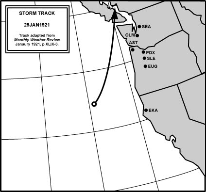
Figure 1, above, is a rough approximation of the January 29, 1921 cyclone's track, based on available information from the January 1921 Monthly Weather Review (MWR). The storm's impact in Oregon was limited, whereas Washington's coastline received one of the strongest gales of the 20th century. Tatoosh Island's maximum winds were out of the SW, informing that the low tracked north of this station. This evidence, among other details, supports a northeast track into southern Vancouver Island, which places this storm among Class 5 events. Hard numbers are difficult to obtain from this time period. Notes from the Severe Storms and other sections of the January 1921 MWR reveal some of the details about this devastating event. The data suggest a storm path similar to other big sou'westers, with an average speed of about 50 mph according to the MWR. Data from other sources will be added as they are located. Note on wind readings from the pre-1928 time period: Four-cup anemometers made out of brass and weighing 550 grams, with cups four inches in diameter, were employed by the Weather Bureau pre-1928. Due to the unique inertial response of the anemometers, readings from a 4-cup system tended to be high when compared to the actual wind velocity. This physical reality was carefully studied in the late 19th century with the results reported in the MWR. What this means is that the 4-cup readings, as reported in the MWR and other sources, need to be adjusted downwards to be comparable to the 3-cup anemometers that were employed from 1928 to approximately 2006 (from about 2003 to 2007, many official cup anemometers were replaced with sonic anemometers). In general, a 4-cup system reads about 9.0% high when indicating 25 mph, 22.5% high when indicating 50 mph, 27.7% high when reading 75 mph and 30% high when reading 90 mph [3]. Original 4-cup figures are shown in the data below, with corrected readings in parenthesis. Correction factors are based on a table provided in early issues of the MWR, and the table accessed appeared in January 1894, Vol. XXII, No. 1, pp 28-29. The table only covers measured 4-cup speeds of 5 to 90 mph. A 2nd-order polynomial was fit to the available data to extrapolate the correction factor for measurments above 90 mph. Coastal Conditions, South to North Point Reyes Light, CA: Maximum 5-minute winds of S 86 (66) mph occurred in the early afternoon. Using a gust factor of 1.3 for a 66 mph wind, the peak instant (1-sec) gust at the lighthouse probably landed in the vicinity of 85 mph. Eureka, CA: Maximum wind velocity indicated for the month of January 1921 was 43 (36) mph out of the N on the 9th, which puts an upper constraint on the peak velocity during the storm of the 29th. The peak gust at Eureka during the storm on the 29th probably didn't exceed 45 mph. M. S. Sierra, Bellingham for Callao, off the Central Oregon Coast: Barometric readings in Table 1, below:
The ship's observer provided further information in this brief report:
|
|||||||||||||||||
|
North Head, WA: The lowest pressure of 28.90" was reached at 15:30 PST, about 2.5 hours later than the Sierra. Before 15:20, the highest wind velocity was 40 (33) mph, and it only took twelve minutes more for the wind to elevate to a 5-minute velocity of SE 126 (92) mph, with an extreme 1-minute average at 150 (106) mph. The anemometer was destroyed by a falling wireless tower before maximum winds had been attained by the storm. Applying a 1.3 gust factor to the 92 mph 5-minute average wind suggests that peak instant velocities approached 120 mph--and may have been higher (the 1.3 gust factor was developed using 1-minute average speeds; I'm being conservative here, mainly due to uncertainties in the 4-cup to 3-cup adjustment at such high wind speeds). Tatoosh Island, WA: Minimum pressure 28.78" at 19:00 PST, and maximum 5-minute winds of SW 110 (83) mph at the same time, with possible instant gusts around 108 mph. Interior Conditions, South to North Portland, OR: Peak 5-minute winds SW 29 (25) mph. Extreme velocity (1-min) 32 (27) mph [4]. Estimated peak instant gust based on 1-min velocity, using a 1.3 gust factor, 42 (35) mph [5]. These wind values are comparible to the S 28 (24) mph with extreme 31 (27) mph observed on January 4, 1921 during a storm that produced Portland's lowest pressure for the month, 29.32". Available barometric readings at Portland in Table 2, below:
|
||||||||||||||||
|
The relatively high barometric pressure readings for Portland (the minimum for the storm was above 29.32"), when considered against the low of 28.90" at North Head and 28.78" at Tatoosh suggest that this storm passed fairly far off the Oregon coast, probably with a strong NE track as it moved into Southern Vancouver Island, which is somewhat of a different interpretation than shown in the storm track map above. This suggests that this storm should probably be included in Class 5 events, storms that make landfall in or north of Washington, instead of Class 6 the northward-trending sou'westers. Note that at North Head, the barometer read 29.43" at 11:40 with a rate-of-fall of 0.08"/hr for the last two hours, so that by 12:00, the barometer was probably at 29.40", making for a -0.16" difference (-5.4 mb) between North Head and Portland. Apparently this got more extreme as the low neared, as the 15:30 minimum of 28.90" minus the lowest possible pressure for Portland, 29.33", yields a whopping -0.43" (-14.5 mb) difference! For comparison, the max gradient for the same measure was -0.27" (-9.3 mb) at 13:00 during the October 27, 1950 windstorm, and just -0.16" (-5.4 mb) at 10:00 during the December 4, 1951 windstorm [6]. And for the similar AST-PDX measure, a peak gradient of 0.37" (-12.4 mb) was established at 19:00 for the Columbus Day Storm of 1962 (the closest match for the 1921 storm), -0.29" (-9.9 mb) at 06:00 during the November 14, 1981 winstorm, and -0.28" (-9.6) mb at 16:00 during the December 12, 1995 windstorm. It appears from the extreme easterly gradient indicated for the January 29, 1921 windstorm that the cyclone was among the most intense in history. Tacoma, WA: Peak 5-minute wind SW 38 (32) mph. Estimated peak gust 49 (40) mph using the standard 1.3 gust factor. Seattle, WA: Peak 5-minute wind S 59 (47) mph. Estimated peak gust 76 (59) mph. Port Angeles, WA: Peak 5-minute wind SE 38 (32) mph. Estimated peak gust 49 (40) mph. Walla Walla, WA: Peak 5-minute wind SE 37 (31) mph. Estimated peak gust 48 (39) mph. |
|
References [1] Information for this and the following statement were reported in the Monthly Weather Review, January 1921, in the Severe Storms section, page 37. [2] This part of the Weather Bureau report was published in the Monthly Weather Review, January 1921, Severe Storms section, page 37. [3] Ludlum, David M. "The American Weather Book." Houghton Mifflin Company. 1982. See bottom of page 59. And Monthly Weather Review, January 1894, Vol. XXII, No. 1, pp 28-29. [4] The data for Portland are from the National Climatic Data Center, Original Monthly Record of Observations forms, U.S. Department of Agriculture, Weather Bureau, for January 1921. [5] This gust factor is the standard for midlatitude cyclones, as described in Simpson, R. H., Riehl, H., The Hurricane and its Impact, p. 204-212. [6] These measures, and those in the following sentence are derived from hourly observations obtained from the National Climatic Data Center, Unedited Surface Observation Forms for Astoria, North Head and Portland, and Local Climatological Data, Portland, for October 1950 and December 1951. |
|
Last Modified: December 30, 2007 | Back | |