Comparative Examination of Windstorms

Class 5 Events

compiled by

Wolf Read

Class 5: Cyclones That Track Just North of Washington and Over Vancouver Island

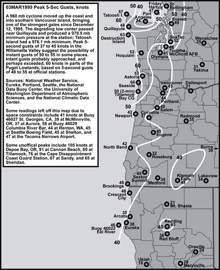
A typical track for Class 5 windstorms is northeast, with the low center landing on Vancouver Island just north of Tatoosh Island, WA, and northward in latitude. This brings a Class 5 cyclone's core north of the region of interest, putting all locations in the storm’s most extreme south side. However, given the far north track, regions south of about the central Oregon coast are generally spared the storm's strongest punch. This, of course, depends on many factors, including the cyclone's depth and the strength of the trailing front. For those lows that happen to be tracking more east than north, the Strait of Juan de Fuca can receive a intense westerly gale behind the storm center as the cyclone tracks inland, setting up a more-or-less ideal pressure graident orientation for this kind of surge.

Very steep gradients can set up over Western Washington as these lows move inland, and this region can receive a very widespread gale. Sometimes, under the right atmospheric conditions, a mesolow can develop in the lee of the Olympic Mountains over the North Inland Waters, and this can result in very extreme wind speeds over a very narrow region. Class 4 storms are probably also capable of generating these mesolows. This can significantly elevate winds in the greater Seattle Area, among other regions in the central Puget Sound. Save for the coastal strip, Oregon is largely spared by these storms, due to their distant track. Only rarely does the Willamette Valley experience high-wind criteria gusts (50-knots or higher) from these storms.

Perhaps the most intense Class 5 event was the 21 Oct 1934 windstorm, an event that occurred before a more consistent peak gust record was established by the Weather Bureau (now National Weather Service). An anemometer at the Seattle Airport, located where Boeing Field is today, recorded maximum 1-minute wind speeds of 58 mph during the storm, the highest average wind reading on record for this location. Structural damage from the storm was widespread throughout Washington, and loss of human life was relatively high--with at least 22 fatalaties, this event is among the deadliest.

15 Jan 1951

15 Jan 1951: This storm not only delivered a pounding gale to much of the coast, but also to the Puget Sound region. Even the Willamette Valley received a strong gale, with some locations having gusts above 50 knots. The very high gust of 65 knots at Sea-Tac, and elevating peak gust readings from Olympia to Seattle, suggest the possibility that a mesolow developed in the lee of the Olympics and perhaps escalated winds in the Puget Lowlands. The far southern reach and broad extent of the gale, and lower wind speeds in the Strait of Juan de Fuca, suggests a storm that tracked more NE than E, and this perhaps explains the broad reach of the storm relative to the central pressure. This event ranked among the most powerful windstorms of the 1950s.

27 Apr 1962

27 Apr 1962: An intense 977 mb low made an unusual late-season strike. Only rarely do significant windstorms arrive in April, and, of those that have, they're usually closer to the beginning of the month than the end. Given its intensity, this storm would have been quite at home in December or January. Perhaps most interesting is that this event occurred in the same year as the early-season (October) Columbus Day Storm, which was then followed by a late-season storm in March of 1963, suggesting that a pattern for intense seasonal-transition-period lows may have persisted during this timeframe. Though many inland locations did not receive high-wind criteria gusts during the 27 Apr 1962 storm, significant tree damage resulted from this storm; deciduous trees full of fresh, new leaves, which add significantly to wind resistance, probably played a role. At the Strait of Juan de Fuca, a strong westerly surge trailed this storm, marking a strongly easterly track for the low. Tatoosh Island had some strong pressure tendencies, with a maximum -4.7 mb/hr fall and +7.1 mb/hr climb, marking a tightly wound-up low, also reflected in a peak +19.1 mb AST-TTI gradient.

13 Feb 1979

13 Feb 1979: For the Hood Canal and northern Kitsap Peninsual, this windstorm was truly an extreme event. Average winds reached at least 70-knots at the Hood Canal Floating Bridge, and perhaps as high as 90-knots, before a large section of the bridge broke up and sank. The cause of these extreme winds was the development of a mesolow in the lee of the Olympic Mountains, a feature that enhanced the pressure gradient to an extreme level and resulted in truly phenomenal wind speeds. This storm is one of the classic examples of Olympic mesolow formation. The mesolow feature may influenced wind speeds as far south as Sea-Tac Airport, which had a gust to 52 knots during this storm, compared to 38 and 46 at Olympia and Tacoma respectively. The Oregon and Washington coast received a very long period of damaging wind from the slow-moving 976 mb low, with some stations being pummeld by gale-force gusts for nearly half a day.

03 Mar 1999

03 Mar 1999: With a minimum central pressure of 960 mb far offshore, this cyclone was a monster. By the time it reached the shores of Washington and Vancouver Island, the low had degraded to at least 976 mb. The mature-and-filling nature of the low likely spared some regions a more devastating gale. As it was, this cyclone produced the most intense windstorm in the region since the 12 Dec 1995 event, especially when considering that maximum gusts at this time were 5-second averages, compared to the "instant" (1-sec) gusts recorded before the era of ASOS (approximately before 1995-1996). Adusted readings put 60 to 70 knot instant gusts on the coast, 50 to 60 knot gusts in the Puget Lowlands, and 45 to 50 knot gusts in the Willamette Valley. The pressure couplet with this storm was strong for much of the region, generally around -3.0 mb/hr during the declension phase followed by +3.0 mb/hr climbs, but not as intense as a number of other storms, particularly some Class 4 and Class 6 events.

Notes

Other notable Class 4 events include 27 Oct 1950, 07 Jan 1953, 09 Jan 1953, 19 Jan 1964, 16 Jan 1986, 07 Jan 1990 and 09 Jan 1990.

Last Modified: September 23, 2007
Page Created: September 23, 2007

You can reach Wolf via e-mail by clicking here.

| Back |