Examination of the January 5-6, 1986 Tree Damage
My final tally of tree loss for the study site is as follows: One living birch, Betula papyrifera, uprooted, and another partially uprooted. There were 9 trees snapped: three living alders (Alnus rubra), one thick Pacific madrona (Arbutus menzesii), one living bigleaf maple (Acer macrophyllum), one living birch (B. papyrifera), and 3 unidentified, but probably small, dead specimens (like the two noted down in Eric's Forest in the journal entry above). Six trees also lost their tops: four living alders (Alnus rubra), one dead alder, and one living bigleaf maple. Not all these trees I listed fell in the study site loctions, which is why the total listed in the stats above is different from the count of 17 listed in this paragraph. Most of the damage in the study sites is listed below, save for the two dead trees that broke in Eric's Forest.
It is noteworthy that no conifer trees were found with major damage from this windstorm (any would have been noted, and thus can be ruled out of being in the unidentified category), a reflection of their apparently greater resilience to gale force gusts in the 35-45 mph range over that of angiosperm varieties of trees. There is some record, however, of Douglas-firs losing large limbs, so this resilience is definitely being challenged at 35-45 mph wind speeds (in gusts). It is also noteworthy that there were hundreds, if not thousands, of trees in these woodlots that did not suffer much damage at all. It is likely that many of the trees that suffered probably had various kinds of weakness that made them more susceptable to the winds of this storm. Here are the ones I measured in detail (woodlots not listed escaped heavy damage from this storm):
Eric's Forest
Specimen #: 05JAN1986001
Location: East Side
Species: Red Alder, Alnus rubra
Damage: Top Snapped Off
Circumference: 14.5"
Diameter: N/A
Break Height: Over 20' (Est.)
Field Description: The top landed in Eric's Creek. Appeared healthy.
Conclusion: No clear reason for this tree to break when others of same species and in same area did not.
--- --- ---
Southern Woodlot
Specimen #: 05JAN1986002
Location: West Side
Species: Red Alder, Alnus rubra
Damage: Top Snapped Off
Circumference: 16.5"
Diameter: 5.25"
Break Height: 16-18' (Est.)
Field Description: The top is about 16' tall itself and has snapped in two upon hitting the ground. The longest section of the top is propped up by a hazelnut bush (Corylus cornata). The top proves to be dead, but it has not rotted yet, so is therefore still very strong; after repeated attempts kicking it, I gave up without so much as cracking it. The rest of the tree is still alive and green (or gray).
Conclusion: Tree most likely broke due to having a dead portion.
---
Specimen #: 05JAN1986003
Location: Extreme West Side
Species: Red Alder, Alnus rubra
Damage: Top Snapped Off
Circumference: 11.625"
Diameter: 3.7" (Avg.)
Break Height: 14-16' (Est.)
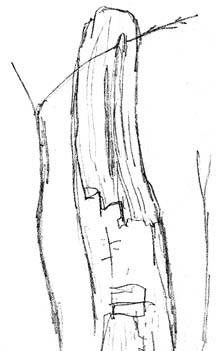
Field Description: The top is about 15' tall and has stuck in the ground like a spear. It is actually one fork of two on the tree. This one was the largest and healthiest of the two. The tree itself has its side opened (at the fork) and its heartwood is rotting badly. The other fork (the one still up) appears to be almost dead. The heatwood of the fallen top has only a slight discoloration and its lower branches are very healthy. The tip of it is dead, however. There is a strip of bark that is missing on the lower end of the top. It is 22" long and is 1-1.5" wide on the lower 12" and 1-2" wide on the upper 10". The wood in this area looks dead, but it has not yet rotted. There are two field sketches of this break.
Conclusion: Tree most likely broke due to heartwood rot, which was probably the product of bark damage.
Field Sketch: To the right, showing broken portion of tree's top. Bark just below the break, seen in the bottom center of the image, has been torn off in a past calamity, and this damage probably contributed to the tree's breaking.
---
Specimen #: 05JAN1986004
Location: N/A
Species: Paper Birch, Betula papyrifera
Damage: Snapped Low
Circumference: N/A
Diameter: 7.5"
Break Height: 6'
Field Description: This tree's heartwood is strong. A hazelnut (Corylus cornata) is holding the birch, which is about 25-30' long, nearly parallel to the ground.
Conclusion: No clear reason for this tree to break when others of same species and in same area did not.
---
Specimen #: 05JAN1986005
Location: West End
Species: Red Alder, Alnus rubra
Damage: Top Snapped Off
Circumference: N/A
Diameter: 5"
Break Height: 15' (Est.)
Field Description: Ten feet of this tree's top fell, hit a dead red alder and snapped the dead tree in half.
Conclusion: No clear reason for this tree to break when others of same species and in same area did not.
---
Specimen #: 05JAN1986006
Location: West End
Species: Red Alder, Alnus rubra
Damage: Top Snapped Off
Circumference: 24"
Diameter: 6"
Break Height: 15' (Est.)
Field Description: This alder was dead previous to the windstorm. Only a little rotted.
Conclusion: Tree most likely broke due to having a dead portion.
---
Southern Woodlot Notes: A Douglas-fir (Pseudotsuga menzesii) in a east-central location lost some big branches, but nothing of a major category (like a top). There were three: one with a 2.5" diameter and 10' long, one 1.875" diameter and 8' long, and one 0.75" diameter and 6' long. A red alder (Alnus rubra) in a central location also lost a large multi-forked branch measuring 3" in diameter and 8' long.
--- --- ---
Northern Woodlot
Specimen #: 05JAN1986007
Location: N/A
Species: Paper Birch, Betula papyrifera
Damage: Uprooted
Circumference: N/A
Diameter: 5.5"
Break Height: Ground Level
Field Description: This 25' tall birch uprooted and got stuck in surrounding trees. Tree is healthy. Took a dead 2" diameter scouler willow (Salix scoulerana) with it.
Conclusion: No clear reason why this tree was singled out by wind; maybe a weak root system due to failing competition with other trees.
---
Specimen #: 05JAN1986008
Location: N/A
Species: Red Alder, Alnus rubra
Damage: Snapped
Circumference: N/A
Diameter: 5"
Break Height: 4'10"
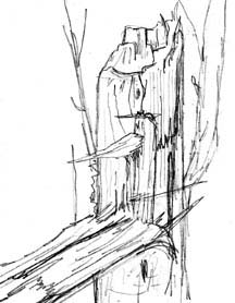
Field Description: This alder was healthy. At least 20' of it is on the ground. Trunk still attached to stump via a sharply bent section of wood about 2" thick at its deepest. Break shows that the alder tree suffered compressive failure (where the attached part of the trunk is) of the down-wind side, and then tensile failure on the windward side (the main break). This fracture has been illustrated.
Conclusion: No clear reason why this tree was singled out by wind.
---
Specimen #: 05JAN1986009
Location: N/A
Species: Paper Birch, Betula papyrifera
Damage: Partial Uprooting
Circumference: 26.675" and 42.5"
Diameter: N/A
Break Height: Ground Level
Field Description: This healthy brich had two trunks, hence the two circumferences. The tree was obviously leaning, having had some root damage, but was still tentatively supporting itself by the roots that remained.
Conclusion: No clear reason why this tree was singled out by wind.
---
Specimen #: 05JAN1986010
Location: East Side
Species: Paper Birch, Betula papyrifera
Damage: Snapped Low
Circumference: N/A
Diameter: 6.25"
Break Height: 6' Above Ground
Field Description: This tree was dead before the storm, and part of it were fairly rotted.
Conclusion: Tree most likely broke due to having a dead portion.
---
Northern Woodlot Notes: A 10" diameter paper birch that was broken by the November 14-15, 1981 windstorms, and suspended in a red alder bough (also 10" diameter) was forced to the ground in the January 5-6, 1986 windstorm. This long dead tree is now blocking a trail. A Douglas-fir (Pseudotsuga menzesii) on the extreme east end lost a 4' long branch with a 1-1.5" diameter (Estimated--the branch is stuck in a tree). It also shed four branches over 1' long in nearby Phillip Arnold Park. Douglas-firs in Phillip Arnold Park shed an enormity of twigs. At least 20 were torn from one tree.
--- --- ---
Trillium Forest
Specimen #: 05JAN1986011
Location: Central
Species: Bigleaf Maple, Acer macrophyllum
Damage: Part of Top Broken
Circumference: N/A
Diameter: 4"
Break Height: N/A
Field Description: This branch, in essence, was 15-20' long. The bough landed tip-first, and two branches from it speared the ground and sheared off the main body. Entire bough appeared healthy.
Conclusion: No clear reason why this tree was singled out by wind.
---
Trillium Forest Notes: A western hemlock (Tsuga heterophylla) on the east-central side lost a 3' long and 0.75" thick branch. This tree is part of a grouping of four, most of which didn't suffer greatly (two nearby hemlocks had been uprooted in the November 14-15, 1981 windstorms). Douglas-firs (Pseudotsuga menzesii) forest-wide lost lots of twigs and branchlets, though nothing of large size.
--- --- ---
 Notes About Entire Field Study
Area: A red alder (Alnus rubra) outside of any of the study woodlots,
but near to the Southern Woodlot (and the Talbot Substation), was broken
at the 5'4" level. The tree was 6.5" in dameter and 20" in
circumference. The field sketch to the right depicts this broken tree. Wood
on the tree's west side was rotting due to previous bark damage, and this
is the probably why this tree broke in the windstorm. Another red alder
in the vicinity, live but with a crescent-shaped cross-section also broke.
It was 8" wide on one axis and 4" on the other, and about 35-40'
tall. It's unusual shape may have contributed to the fall--though it must
be noted that this tree endured many other windstorms in the past (such
as Nov 1981 and Nov 1983). The field sketch below shows the cross-section
of this alder. A dead red alder, also in the region, snapped at the 10'
level: it had a 19.25" circumference and a 5.25" diameter. The
wood had not rotted and was still quite hard. These trees are all outside
the woodlots being examined, so aren't included in the main database. They
are included here as supporting evidence to the idea that biological factors
play a significant role in determining which trees break during typical
winter gales.
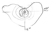
Notes About Entire Field Study
Area: A red alder (Alnus rubra) outside of any of the study woodlots,
but near to the Southern Woodlot (and the Talbot Substation), was broken
at the 5'4" level. The tree was 6.5" in dameter and 20" in
circumference. The field sketch to the right depicts this broken tree. Wood
on the tree's west side was rotting due to previous bark damage, and this
is the probably why this tree broke in the windstorm. Another red alder
in the vicinity, live but with a crescent-shaped cross-section also broke.
It was 8" wide on one axis and 4" on the other, and about 35-40'
tall. It's unusual shape may have contributed to the fall--though it must
be noted that this tree endured many other windstorms in the past (such
as Nov 1981 and Nov 1983). The field sketch below shows the cross-section
of this alder. A dead red alder, also in the region, snapped at the 10'
level: it had a 19.25" circumference and a 5.25" diameter. The
wood had not rotted and was still quite hard. These trees are all outside
the woodlots being examined, so aren't included in the main database. They
are included here as supporting evidence to the idea that biological factors
play a significant role in determining which trees break during typical
winter gales.
--- --- ---
Discussion of January 5-6, 1986 Windstorm Tree Damage
As I progress through the storms of January 1986, and their tally of broken trees, there will be a developing discussion about the results. Just note that in six cases (46%) of tree breakage from the January 5-6, 1986 windstorm, the specimens were not healthy in some clearly visible aspect, often pertaining to damage to the heartwood or outer wood, or the tree simply having died at an earlier date. And it is arguable that those apparently healthy trees that succumbed to this storm may have been losing in the resource competition with neighboring trees--maybe they were being crowded out, and thus had weaker roots and trunks than the others. Even sticking with the 46%, with this storm, there's growing evidence that winter gales seem to be nature's way of "clearing out the deadwood," in essence, which is partly where the intent of this study is going. Also note the species that suffered breakage. Almost all of the trees detailed are either red alder or paper birch. Is this a suggestion that some trees are more susceptable to wind than others? I think it does, but to make the conlusion less ambiguous, I'd have to note the relative abundance of each tree species in the woodlots, which I haven't done to date (though I may take a closer look at this one day). Certainly, there were (and still are) far more alders and birches than, say, Douglas-firs and western hemlocks in the study stie. Some of these woodlots, like the Mine Woods and The Forest, are virtually devoid of conifers. The Trillium Forest has the highest density of conifers, but angiosperms still abound, especially bigleaf maple, which exists in pure stands in some locations. Other variables have to be weighed, too. A tree's relative resistance to wind can be a player in how susceptable it is to a particular storm--conifers, by nature of their dense array of needles, probably offer more resistance to wind during the winter months than do alders (and in the case of this study, which was in January, all the deciduous trees were barren of foliage). And most conifers are taller than their angiosperm cousins, which puts them more directly in the path of the wind. Nothing is simple in my crude attempt to quantify the effects of windstorms on trees.