Kona Storms and Winter Weather in WA State
March, 2019
As detailed here, the month of February 2019 will long be remembered for its snowy weather, especially in the lowlands of western Washington. We are not the only place that has experienced some unusual conditions – here we direct our attention to Hawaii, and in particular the “Kona” storm that slammed the state during the second week of the month. We hypothesize that there is an association between Kona storms, sometimes termed Kona lows, and cold weather in Washington state.
That such a connection might often exist is based mostly on conversations over the years with NWS personnel in the Seattle office. But we have not unearthed any published research on the subject, and the present treatment is exploratory at best.This seems to be the right kind of forum to bring up the topic, and we encourage readers to weigh in. An animation of the jet stream during some of the unusual February weather, as well as an additional discussion of Kona lows, can be found here.
Kona storms represent unusual weather conditions for the subtropical North Pacific Ocean. While they ply their wares south of the usual North Pacific storm track, they generally include a cold core aloft, and hence are best characterized as mid-latitude cyclones. Based on the 10-year climatology of Otkin and Martin (2004), about a dozen of them occur per winter, with about 2-3 of these having direct impacts on the weather of the Hawaiian Islands. Among these aspects is a reversal of the usual trade winds from the northeast, and heavy rains in the generally drier, leeward portions of the Hawaiian Islands. These storms also often feature high surf and even snow at higher elevations. The paper by Otkin and Martin (2004) shows that a ridge of high pressure aloft occurs to the east of the cyclonic circulation near the surface. The development of this ridge is presumably related to the southerly winds and warm advection in this sector of the storm. And conceivably such a ridge of sufficient amplitude and at the right longitude would help deliver cold air to the Pacific Northwest.
We sought to examine this kind of linkage between Kona storms and our winter weather. Towards that end, we rummaged around for a listing of Kona storm events, but failed to come up with anything resembling a comprehensive list. We did find 8 examples of past events based on archived reports and news articles. They are certainly skewed towards events that were noteworthy for the Hawaiian Islands. Since there are plenty of disturbances that remain too far north to have important effects on the islands but could still be important features of the winter weather over the North Pacific, our survey is very much incomplete. But here goes anyway.
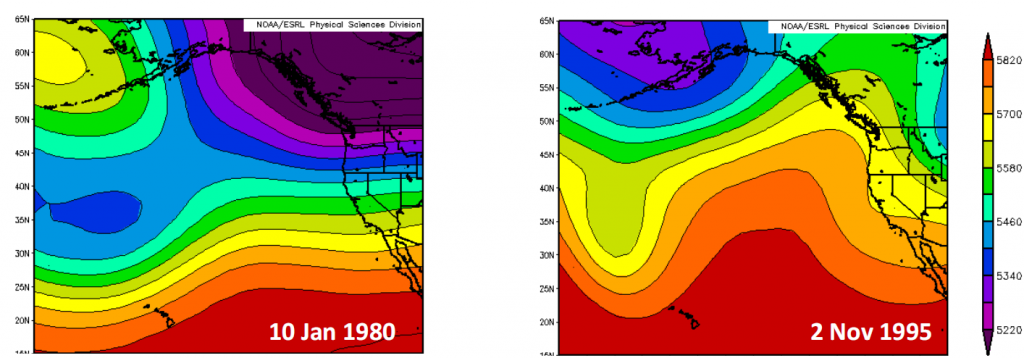
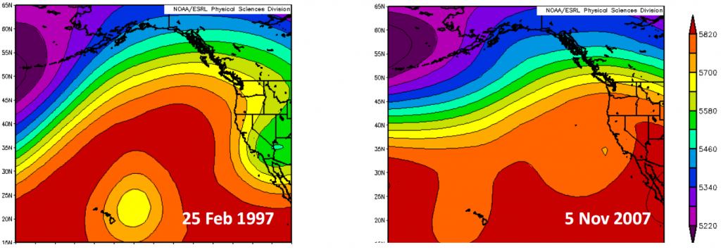
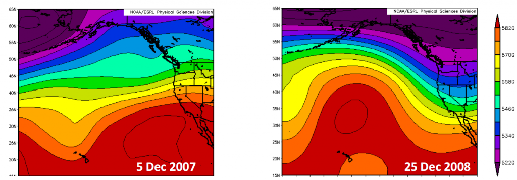
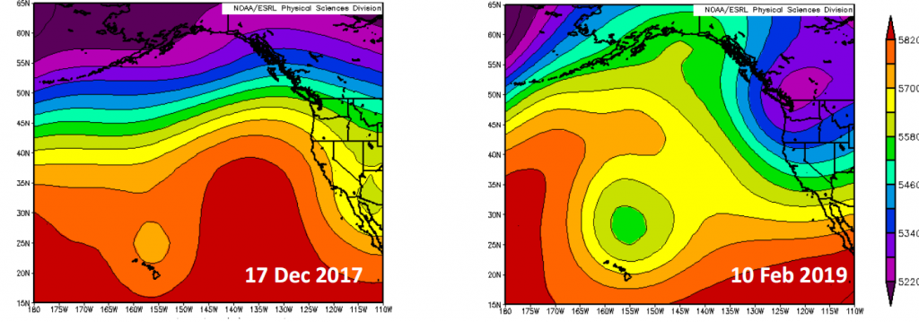
For the 8 events selected, we made maps of 3-day means of 500 hPa geopotential heights, as shown in Figure 1. Hopefully these examples are representative, but again we are not claiming that is necessarily the case. The set of maps in Figure 1 include some commonalities but also plenty of differences. The two stronger Kona lows in this set are the earliest one in January 1980 and the latest one in February 2019 (the maps in the upper left and lower right, respectively) and both periods also feature low 500 hPa heights over British Columbia in a cold pattern for the Pacific NW. All of the cases included some ridging to the northeast of the Hawaiian Islands, but the flow near the west coast of North America was manifested in a variety of ways. Based on our superficial analysis, we are hard-pressed to make much in the way of generalizations, with only about half of the cases featuring lower than usual 500 hPa heights over WA. On the other hand, a majority of the patterns are favorable for colder than usual weather in WA, to varying degrees.
Our results are no great surprise in light of the myriad factors acting on the mid-latitude atmospheric circulation. Moreover, it is close to impossible to distinguish between cause and effect in that transient disturbances such as Kona lows develop when the long-wave atmospheric pattern is favorable as well as potentially helping maintain the pattern. In other words, perhaps the development of our cold weather in some ways helped promote the formation of a particularly strong and impactful Kona storm. We close with the thought that there must have been folks fleeing WA to bask in the sun in Hawaii that received a rude surprise, but we expect they would not get much sympathy from the rest of us trudging through the snow.