The April 14, 1957 Classic Sou'wester compiled by Wolf Read |
|
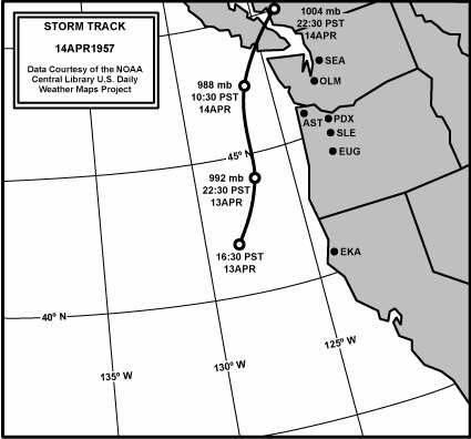
Introduction In mid-April 1957, a strong 988 mb low developed off of Northern California and moved north offshore along about 127 west longitude. This is the classic "inside 130 west longitude" path, one shared by such notorious windstorms as Columbus Day 1962, November 14, 1981 and December 12, 1995. The late-season nature of this storm makes it particularly interesting. Significant April wind events are rare, and only occurred about once per decade in the era of the 1957 storm. Other April storms include a Western Washington gale on April 23, 1943, a broader strike on April 27, 1962 and a tornado-producing squall on April 5, 1972. Since 1972, there apparently haven't been any significant April windstorms, which approximately coincides in time with the disappearance of the occasional October windstorm, the last big event being October 2, 1967. This change may be related to the Pacific Decadal Oscillation, which underwent a major shift to "warm phase" conditions in 1976-77, or it simply may be the product of a strongly random nature to wind events. In California, According to the NCDC's Climatological Data for April 1957, this storm was mostly noteworthy for heavy rain, which included a 6-hour total of 1.93" at Ukiah. Winds became particularly damaging locally in Crescent City, where a hotel's carports were demolished. In Oregon, one person was seriously injured by a falling tree in Estacada (Climatological Data, April 1957). Power was disrupted by numerous fallen trees and some broken poles, especially in the Northwest section of the state. Portland suffered a fairly heavy blow, with the superstructure of a new market folding, and two ships broken from their moorings and carried destructively into the Hawthorne Bridge. In Washington, one person was killed when his boat overturned on Lake Cavanah, and another was killed near Olympia by a windthrown tree (Climatological Data, April 1957). Power interruptions occurred over much of the state, and the high winds east of the Cascades resulted in a major dust storm. Gradients and pressure tendencies with this storm weren't particularly unusual for a strong winter-type storm. To explain some of the higher gusts, especially inland, like 69 mph at Portland and 62 mph at Boeing Field, it's possible that strong convection may have had a hand in the powerful gusts at these locations. For example, Boeing Field's peak gust was a fairly isolated occurrence about three hours ahead of more steady blustery winds which peaked at 43 mph. The 62 mph gust was associated with a wind shift from S to SW, the mark of the passage of a frontal system. Light rain showers ended within an hour of the max gust. Portland's peak gust isn't associated with a wind shift, but a drop in temperature from 53 F to 47 F with the onset of light rain showers. The temperature drop also suggests frontal passage. The stronger rays of the April sun may have enhanced convection along the front, which may have mixed down the stronger wind gusts. A confounder to this interpretation is that Boeing's peak happened around 06:35 HRS, which excludes strong Solar warming. Portland's works, for the peak gust happened at 11:55 HRS. The early arrival of peak gust at Boeing in reference to Portland suggests a unique origin for the brief burst of heavy wind. Two frontal systems is the likely answer. Eugene showed a similar pattern to Boeing, with the arrival of the first, brief round of gale wind about four hours earlier. These local bursts were clearly spotty, and may have been convective in nature even without direct solar warming. Figure 1, below, details the April 14, 1957 storm's track, with central pressures and times noted. The broad arc north of Washington, which put the state south of the low for a protracted time, likely contributed to a prolonged period of breezy conditions in the state, and the high winds east of the Cascades. |
|
General Storm Data Minimum Pressures and Peak Gradients Table 1, below, is a list of the lowest barometric pressures, and time of occurrence, for the April 14, 1957 windstorm. Though low compared to annual sea-level pressure averages, these values aren't particularly striking when compared to a number of windstorms, including the event of April 27, 1962. Source: Microfilm copies of the unedited surface observation forms, obtained from the National Climatic Data Center. |
Table 1 Notes: [1] Last of two occurrences, the other having happened in the hour before. [2] Based on altimeter reading. [3] Last of two occurrences, the other having happened in the hour before. [4] Last of four occurrences, the others having happened from 04:00 to 06:00. Figure 2, below, tracks the cyclone northward up the coast, with some deepening indicated. The secondary dips at Astoria and more strongly at Tatoosh Island are likely the result of the low arcing inland north of Washington. The strongly progressive dips are a general feature of the classic windstorm pattern. |
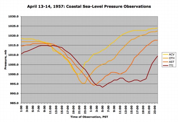
Table 2, below, is a list of the maximum pressure gradients, and time of occurrence, for the April 14, 1957 windstorm. These values are fairly strong, but they are significantly short of the extremes seen in the major classic windstorm events, like the Columbus Day storm, November 14, 1981 and December 12, 1995. Source: Microfilm copies of the unedited surface observation forms, obtained from the National Climatic Data Center. |
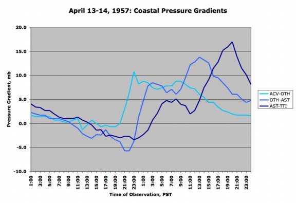
Figure 3, below, shows the trend in coastal gradients during the April 14, 1957 windstorm. For each region, after an initial period of negative gradient due to a cyclone position south of the stations, the gradient quickly swung positive. The quick polarity shift is likely the result of the storm's leading front passing through the region. The secondary peaks, which mark the maximum gradients for the northern measures, likely demark the closest passage of the cyclone's center. |
Pressure Tendencies The April 14, 1957 windstorm brought with it a fairly standard "pressure couplet" over for a decent storm in the Northwest, with strong pressure surges (+3.0 mb and higher) generally reserved for coastal stations. Table 3, below, shows the maximum hourly changes in pressure for eleven key stations in the Pacific Northwest. In a rare occurrence, Arcata showed the most active barometer. Usually northern stations get the strongest pressure effects from classic events. Likely, this was the result of a fairly potent frontal system associated with the storm. Source: Microfilm copies of the unedited surface observation forms, obtained from the National Climatic Data Center. |
| ||||||||||||||||||||||||||||||||||||||||||||||||||||||||||||||||||||||||||||||||||||||||||
Table 3 Notes: [1] The -2.0 mb hourly fall at Olympia is the last of two occurrences, the other instance having occurred at 22:00. [2] The +2.6 mb hourly climb at Sea-Tac is the last of two occurrences, the other instance having occurred at 08:00. |
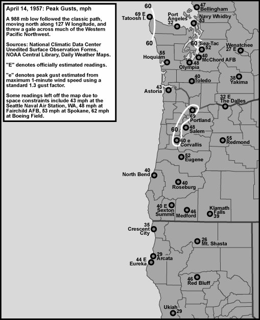
Peak Wind and Gust Table 4, below, lists the peak wind and gust for eleven key stations in the Pacific Northwest, their direction, and their time of occurrence. "Peak Wind" is a 1-minute average, and "Peak Gust" is an instant (approximately 1-second) average. By my own personal methodology, a wind event rates the term "windstorm" when the average peak gust of these eleven stations reaches 39.0 mph (gale force) or higher. The April 14, 1957 windstorm ranked as a moderate windstorm. Moderate windstorms have an average of 45.0 to 54.9, and major windstorms are those that reach or exceed 55.0. Only a handful of storms have made the majors, including December 12, 1995, November 14, 1981 and October 12, 1962. This ranking favors those cyclones that follow a northward path close to the U.S. Pacific Coast, and for good reason--such storms affect the largest land area, and therefore are potentially the most destructive. The April 14, 1957 windstorm produced an atypical peak gust distribution in Western Oregon, which is probably why this storm didn't rank higher. The fastest gusts at these official stations struck the Willamette Valley, especially the north part. Usually the coastal stations take the lead. It appears that the establishment of a coastal low-level jet did not happen, or only occurred in weak form compared to other storms of history. It should be noted that peak gusts of 60 to 75 mph are mentioned for the coast in the April 1957 Climatological Data for Oregon, but locations are not specifically noted. Another interesting result was the relatively low wind speeds at Arcata, despite this location having the strongest pressure changes during the storm. Apparently the gradient orientation just wasn't supportive of high winds during the time of maximum pressure swings. For an inland station, Portland got a particularly strong wind. Indeed, a peak fastest mile of 60 mph was noted for 11:53 HRS--that converts to a 60 mph 1-minute wind. Since fastest mile isn't generally used in these tables, the peak 1-minute velocity of 52 mph on form WBAN 10A is used (incidentally, the peak 1-minute wind is noted as 49 mph on form 10B, so there was a bit of confusion at Portland on that day). Average winds of 50 to 60 mph can be quite damaging to tees. This is right at the threshold for local swathing. Source: National Climatic Data Center, unedited surface observation forms. |
| Location | Peak |
Direction |
Obs Time of |
Peak |
Direction |
Obs Time of |
| California: | ||||||
| Arcata [1] | 21 |
SW |
00:28 HRS, 14th |
29 |
SW |
00:28 HRS, 14th |
| Oregon: | ||||||
| North Bend | 23 |
SW |
13:28 HRS, 14th |
40 |
SSE |
07:28 HRS, 14th |
| Astoria | 28 |
S |
03:28 HRS, 14th |
43 |
S |
04:28 HRS, 14th |
| Medford | 29 |
WSW |
07:50 HRS, 14th |
46 |
WSW |
07:50 HRS, 14th |
| Eugene | 35 |
SSW |
02:28 HRS, 14th |
52 |
SSW |
02:28 HRS, 14th |
| Salem [2] | 31 |
S |
11:28 HRS, 14th |
48 |
S |
11:28 HRS, 14th |
| Portland | 52 |
S |
11:55 HRS, 14th |
69 |
S |
11:55 HRS, 14th |
| Washington: | ||||||
| Tatoosh I. | 57 |
S |
18:54 HRS, 14th |
69 |
SSW |
19:15 HRS, 14th |
| Olympia | 37 |
S |
11:47 HRS, 14th |
48 |
S |
11:47 HRS, 14th |
| Sea-Tac | 40 |
S |
13:06 HRS, 14th |
52 |
S |
13:06 HRS, 14th |
| Bellingham | 30 |
SE |
22:19 HRS, 14th |
47 |
SE |
22:19 HRS, 14th |
| AVERAGE | 34.8 |
SSW |
49.4 |
S |
Table 4 Notes: [1] Peak gust at Arcata is the last of several occurrences, the others happening at 18:28, 19:28 and 20:28 on the 13th, all out of the SE. [2] Peak wind at Salem is the last of two occurrences, the other having happened the hour before. |
Last Modified: April 1, 2004 You can reach Wolf via e-mail by clicking here. | Back | |