 |
|

Plot Reference Point(s)
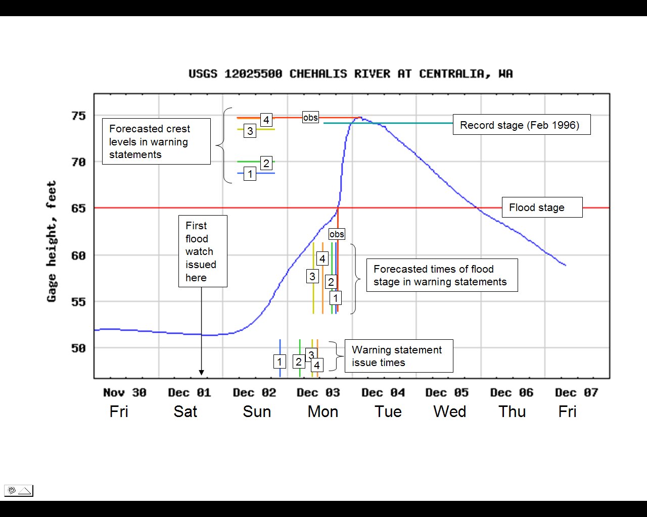
Use this for plotting 1 or more reference points to assist in finding stations in and around a particular location. Enter an address, city, zip code or latitude and longitude coordinate into the box below. (Examples: "4909 25th Ave NE, 98195" or "Seattle, WA", or "48.456,-122.225") Close Window 12/8/2007 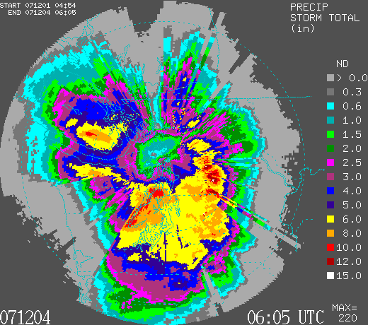 Western Washington radar estimated total storm precipitation for the period 05 UTC December 1, 2007 through 06 UTC December 4, 2007. December 1st marked the first in a series of 3 storms to move over the Pacific Northwest from December 1-3, 2007. With cold arctic air already in place over the region, the first storm produced heavy snow in the mountains and low-land snow throughout western Washington. Around Seattle, up-to 1" of snow fell while many areas away from Puget Sound received over 4" of snow. Reported snowfall totals. On December 2, the snow changed over to rain as temperatures increased along with the wind. As a low pressure system moved over the Olympic Peninsula, wind gusts of over 80 mph were observed along much of the coast (Hoquiam 81, Destruction Island 93, Tatoosh Island 86) and 40 to 50+ mph inland (Olympia 44, Seattle 48, Bellingham 53). Analysis of the windstorm. The most significant of the three storms arrived the next day with near record high temperatures (59°F for Seattle) and moist tropical air which led to record rainfall and flooding around western Washington. Preliminary estimates indicate that 6-hour and 24-hour precipitation amounts were near 100-year rain frequency levels. The 24-hour maximum precipitation totals for Sea-Tac AP 4.16", the Seattle Weather Forecast Office 4.56", Olympia 3.80", Chehalis 5.38" and Shelton 6.42". For Sea-Tac AP, December 3, 2007 became the 2nd wettest day on record with 3.77" (first is 4.93" recorded on October 20, 2003) and the wettest day on record for Bremerton which received 7.50" of rain breaking the old record of 5.62" set December 10, 1921. See the map below for additional western Washington precipitation totals. According to the United States Geological Survey (USGS), the intense rainfall led to major flooding in southwest Washington and moderate flooding in central western Washington. About 10 sites reached new all-time record high river flows and set all-time record high flood stage levels, including the Chehalis which reached nearly 75 ft (10 feet over flood stage), breaking the previous record set in the floods of February 1996. The flooding of the Chehalis river led to widespread flooding throughout western Lewis county, including a stretch of I-5 (DOT Images), forcing 20 miles of the interstate to be closed for 4 days. Despite advanced warning by the National Weather Service, the flooding caught most people off guard, keeping the coast guard occupied as they rescued more than 300 people from the flood areas. The flooding and mudslides have resulted in at least 5 deaths and have prompted the declaration of 6 counties as federal disaster areas by the President.
Related Links
|


 |